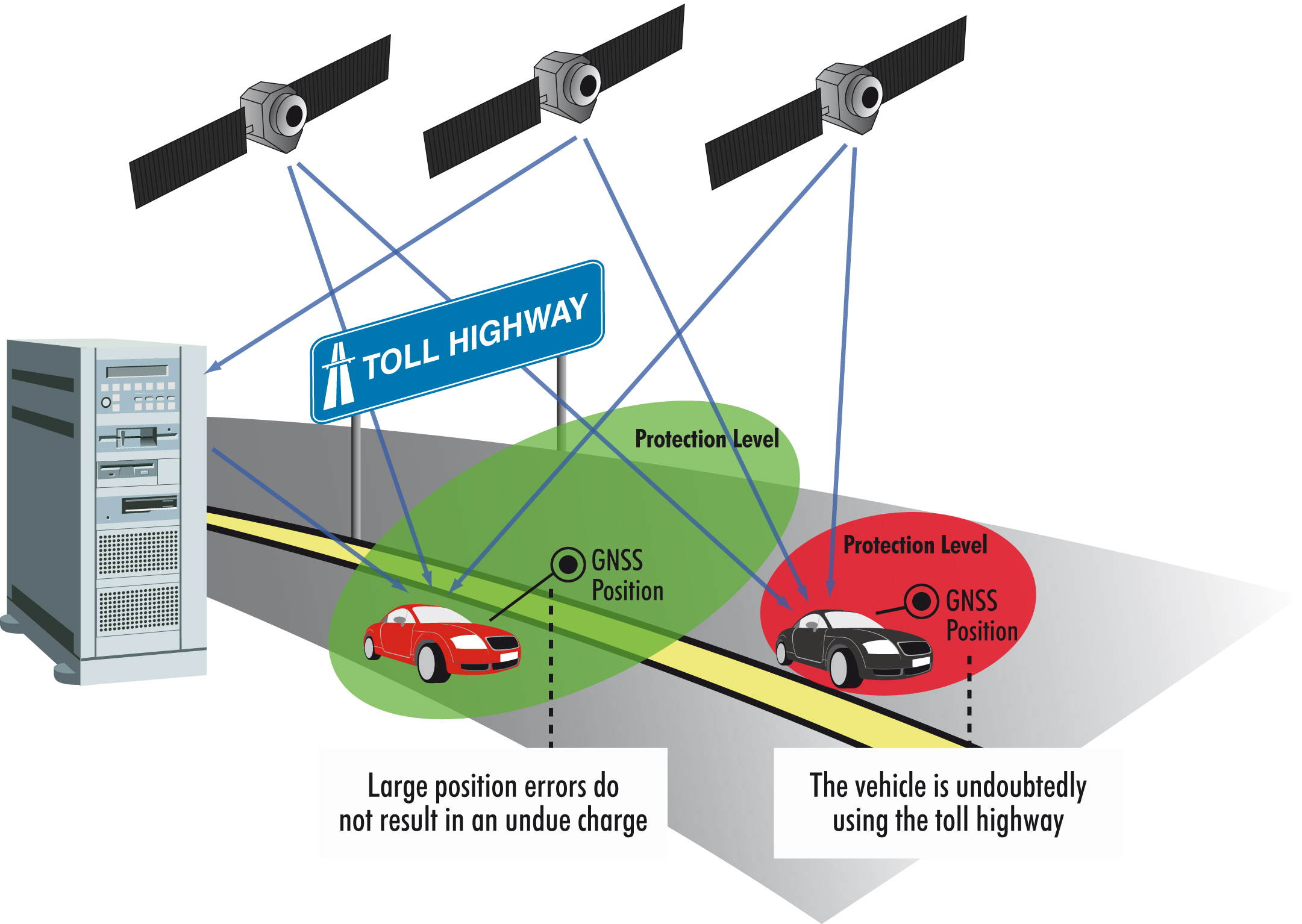
GINA will look at how to improve the positional accuracy of GNSS-based road user charging systems and so help to address issues such as overcharging and loss of revenue.
The European GINA project is intended to address and overcome many of the institutional, technical and public acceptance hurdles currently faced by satellite-based road user charging schemes. Dave Tindall and Denis Naberezhnykh, TRL, and Laure Dezes, ERF, write.
Pay-as-you-drive Road User Charging (RUC), whereby demand (or congestion) is managed by applying appropriate tariffs in order to encourage drivers to make their journeys at less busy times, on less congested routes or even on different modes, could facilitate a change in the way roads are paid for and also reduce the environmental impact of road transport. RUC schemes are already in place for Heavy Goods Vehicles (HGVs) using strategic roads in several European countries and there are ambitions to extend the charging of HGVs further. The Eurovignette Directive (1999/62/EC amended by 2006/38/EC) provides an example of this.Satellite-based RUC schemes, also referred to as GNSS (Global Navigation Satellite System)-based schemes, have a number of perceived advantages where application over larger geographic areas and a wider range of vehicle classes is concerned. Not least, there is a presumption of the need for less fixed infrastructure and, therefore, a reduction in cost. However, they face a number of technical, economical and social hurdles that have proven to be difficult to overcome.
Firstly, no-one has ever attempted a national GNSS-based RUC system before, so the technical and economical feasibility of such a system is not yet proven. Furthermore, the benefits of a GNSS-based RUC system relating to reductions in congestion and pollution are not yet fully understood on a national level. This can make it difficult to achieve public support and acceptance; there is often an overwhelming public perception that RUC will simply be an additional way to charge road users. Due to the limitations in accuracy and availability arising from GPS technology, especially in environments such as urban canyons, it has been difficult to ensure that the probability of overcharging a user is sufficiently low. Issues with data integrity and security, as well as user privacy, also need addressing.
GNSS-based RUC is still considered to be in its infancy and, as such, there is a lack of standards for this application. Interoperability of RUC systems is likely to become important in the future. Any solution adopted now in Europe should be in line with, and based on, the
RUC in the Netherlands
The Netherlands, which proposes to implement a national charging scheme to replace vehicle purchase and road taxes, is pioneering national GNSS-based RUC, through its ABvM (Anders Betalen voor Mobiliteit or Alternative Payment Method for Mobility) programme.The Dutch Government has already conducted a technology testing programme in which the technical capabilities of GNSS systems and the potential enhancements have been investigated. This testing, which was led by the UK's
However, the Dutch Government is likely to face some challenges due to the scope and complexity of a national RUC system. The task of ensuring over 8 million vehicles are equipped with an OnBoard Unit (OBU) for tolling and investigations into certification of the scheme along with ensuring physical and data security are just some of the challenges. Users' privacy is of prime concern, with data and quality management processes necessarily being secure and robust.
Performance assessment
In order to build up public and stakeholder confidence in RUC schemes, large-scale trials to assess system performance should be undertaken. This has been shown repeatedly through the experience of TRL, which has played an active role in many European Union projects and government trials over the past 15 years. Trials can also help to improve the understanding of the social and economic impacts of a nationwide system and identify potential solutions to any technical performance issues.Since the Dutch Government is expecting to use the ABvM RUC scheme to replace some of the taxes associated with road transportation, participation will be compulsory for all Dutch road users and it must be operated correctly and fairly. This is made even more important by the fact that the scheme is to be implemented in an open, competitive market and thus a number of different companies will be able to sell services to road users. In this scenario it is important to ensure that all parties involved follow procedures that instil trust in fair, accurate and secure charging of road users. This is best achieved by independent agents which assess processes by using a comprehensive and approved certification system.
The GINA Project
GINA (GNSS for Innovative road Applications) is looking to discover whether national RUC systems using today's GNSS technology can offer a feasible solution to the challenges faced.GINA is an EC 7th Framework Programme project involving 12 partners. Its objectives are threefold: to demonstrate the benefits of the European Geostationary Navigation Overlay Service (EGNOS), compared with GPS only; to gain evidence of the added value of position integrity for RUC; and to prove the system's ability to minimise the level of overcharging which should help to increase the system's accuracy and increase confidence in the concept of RUC.
To achieve these goals, the GINA project has defined a complete procedure, starting with an analysis of the design and implementation context (legal, regulatory, interoperability and standardisation) and ending with the execution of a large-scale demonstration of a GNSS-based nationwide RUC scheme. This will include value-added services such as pay-as-you-drive for vehicle leasing companies, traffic information generation, modelling and distribution. More precisely, starting in spring 2010 and lasting for six months, 100 volunteer cars equipped with a sophisticated OBU will circulate on the Dutch network and have their travel data recorded.
GINA will put EGNOS technology through an end-to-end trial to ensure it is technically ready for deployment when the first all-roads, all-vehicles system goes live. This demonstration will also test the technology's performance and cost-effectiveness compared with standard GPS. It is recognised that the GPS signal does not always meet the accuracy, integrity, availability and continuity requirements critical to avoiding overcharging of drivers or loss of revenue to the road operator. In this context, GINA's use of position integrity to prevent large position errors going undetected is expected to improve the accuracy of charge calculation in RUC systems.
Beyond this major technological feature, GINA plans to implement a real RUC prototype, encompassing all relevant aspects and thus demonstrating the full potential of GNSS-based systems. As such, the project will identify the user needs for: the whole value chain; the service requirements; the necessary architecture to provide these services; and the economic aspects of the service set-up.
The objective of GINA is to develop services that will be deployed in the very near future. One of the most innovative aspects of the GINA trial lies in the use of real end-user technical and commercial requirements as a reference to design and analysis.
Being the first example of a nationwide GNSS-based RUC scheme, GINA proposes to use the current requirements of the Dutch model as a benchmark for setting up its large-scale trial. Furthermore, GINA can count on the active contribution of the consortium partners which represent end users (ARVAL, a car leasing company, AENOR, a Portuguese road operator, and CENIT, a Spanish R&D centre) to ensure realistic end user requirements and operation.
GINA will contribute to the definition of a viable, innovative RUC scheme in which satellite navigation technology is the core element, and give a boost to public and stakeholder acceptance. From a business viewpoint, GINA's future business model should help define the strategy to overcome existing barriers preventing mass introduction of RUC and value-added services. Capitalising on previous EC research projects outcomes, GINA is willing to propose a mass-market strategy indicating clear penetration prices and fee structures. This also includes a perspective on the provision of value-added services using the same technical platform which delivers the RUC service. Indeed, the same OBU and central infrastructure can be used for multiple services (pay-as-you-drive and traffic information in the specific case of GINA).
By demonstrating the first end-to-end, large-scale GNSS-based RUC system, the project will provide a unique opportunity to overcome some (or ideally all) technical obstacles and understand the complex implementation and operational procedures enabling mass market use. Furthermore, the results of the trial in terms of the benefits of EGNOS position integrity could influence the future adoption of EGNOS and Galileo in transportation. If these benefits are proven and the charging errors are within defined performance levels, one can expect a greater interest from stakeholders towards innovative satellite technologies.
Conclusion
Today, although different tolling technologies already exist, an infrastructure-light system is undoubtedly ideally suited for large-scale deployment. But much remains to be done to address the technical, commercial and social issues. GINA, through its work on the use of EGNOS to improve position integrity and guarantee an acceptable level of overcharging in particular, is looking to address those issues and offer a solution. If successful, EGNOS, and later Galileo, could help to resolve many of the technical issues which until now have been associated with GNSS-based RUC schemes.With the future adoption of the Eurovignette Directive, one can hope that the most innovative, flexible and cost-effective solution will be adopted. If so, the proposed GINA technology may become a future platform of choice for GNSS-based RUC.


