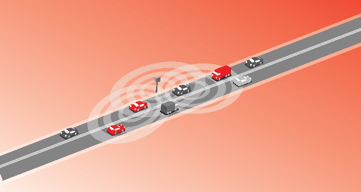
Detection of time at sensor using Bluetooth
New trials show Bluetooth and Wi-Fi signals can be reliably used for measuring travel times and at a lower cost than an ANPR system, but which is the better proposition depends on many factors.
Measuring travel times has traditionally relied automatic number plate (or licence plate) recognition (ANPR/ALPR) cameras capturing the progress of vehicles travelling along a pre-defined route. Such systems also have the benefit of being able to count passing traffic and have become a vital tool in dealing with congestion and pollution in many cities. However, ANPR systems require high quality cameras with fast frame rates to capture an image of the number plate with enough definition for the system to define the vehicle’s registration number. Such cameras are relatively costly to install and maintain.
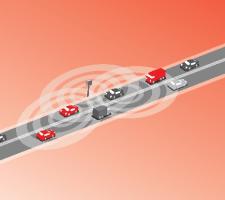
Now, with the rise of the mobile phone, in particular the smartphone, hands-free kits in cars and tablet computers, it is becoming increasingly possible to monitor traffic flows using Bluetooth and Wi-Fi signals. While not all vehicles contain mobile phones emitting Bluetooth or Wi-Fi signals, the proportion that do is now high enough that, according to system suppliers, meaningful travel time data can be obtained by tracking signals from such devices.
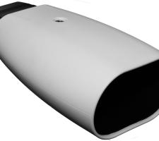
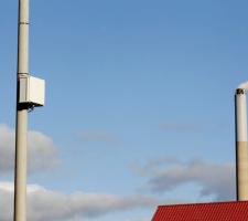
One such supplier, the Danish company3778 Blip Systems, has undertaken trials to demonstrate that collecting travel time information and congestion data using Bluetooth and Wi-Fi can be as accurate as ANPR and, it claims, at a fraction of the cost. One such trial compared the results from ANPR- and Bluetooth-based systems along a four lane (two in each direction) carriageway in the city of Aalborg, Denmark. Four ANPR cameras were already installed along the route which covers around 4.25km and has six sets of traffic signals. To enable a comparison to be made two BlipTrack Bluetooth sensors were installed, one at either end of the test route. The sensors were mounted on the same posts as two of the ANPR cameras.
Lars Tørholm Christensen, chief technology officer at Blip Systems says: “Cameras cost much more than our sensors and our solution requires a single roadside sensor, whereas a camerabased solution requires a camera over each lane. This implies multiple cameras per site and much higher installation cost since an arc over the road must be made, the road must be closed and so on.”
The sensors detect the Bluetooth signals emitted from the smart phones carried by individuals and utilised in hands-free installations in vehicles. However unlike number plates, pedestrians and cyclists also carry smartphones as do passengers on buses which make frequent stops, and drivers that park or make a U-turn within the monitored area. In order to prevent the recorded travel times from these devices distorting the actual travel time calculation, the software uses a moving average-based algorithm which excludes travel times far outside the medium to reveal the actual average speed of the traffic.
When there is a problem and the traffic slows, the average travel time will extend with Bluetooth tracking in the same way as it does with ANPR. Even when traffic is very slow Tørholm Christensen says the system can produce clean data: “We can filter the data so we only get data from vehicles.” While not going into details, he says the system is “robust and bulletproof” and that there are also solutions for isolating data from bicycles, enabling separate reporting of travel times for bicycles and vehicles.
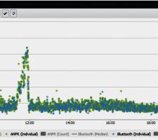
There were no such problems in the Aalborg study as the road monitored was not heavily pedestrianised. What it did reveal was that the number of vehicles detected using Bluetooth was typically between four and five times lower than with ANPR. According to Blip the proportion is high enough to give meaningful data and its sensors recorded between five and 30 complete signals (entry and exit) every 10 minutes. The median travel times calculated by both systems over the trial period were typically within a few seconds of each other and the Bluetooth data detected major congestion as quickly as the ANPR system.
Detection rates can be increased to around 50% by using a new combined Wi-Fi and Bluetooth sensor, as was evident from a second trial carried out in America. Again the Wi-Fi signals detected by the combined sensors are from smartphones and the travel time readings from the Wi-Fi and Bluetooth systems were virtually identical although there is no comparison with an ANPR-based system.
However the data from the second trial indicated that 20% more vehicles were identified by WI-Fi than Bluetooth and Wi-Fi had a particular advantage in the morning peak. Sample counts over a five-minute period topped 30 for Wi-Fi while Bluetooth peaked at around half that figure. And again pedestrians, cyclists and stopping traffic such as busses were excluded.
While Blip does not market its system for traffic counting, sales director Preben Andersen says: “Already the combined Bluetooth and WI-Fi sensor detects around 50% of vehicles and this proportion will only increase as smartphone and hands-free installations become more prevalent.”
Sensor installation takes around one hour and the data is transmitted via the Ethernet or 3G to a cloud-based host so hard wiring is kept to a minimum, making temporary Bluetooth and/or Wi-Fi based travel time measurement systems financially possible. These can be used, for instance, to monitor traffic flows in work zones or to determine the optimum timing and sequencing of traffic lights. All that is required is a convenient mounting point and a 5W electricity supply meaning a system could be powered by a solar panel/battery combination for use in remote or temporary locations such as the approach to roadworks. However, Tørholm Christensen is keen to point out that unlike image-based travel time detection, the Bluetooth/Wi-Fi-based system is unaffected by snow, ice, smoke, fog or heavy rain.
Where there are parallels is in the anonymity of the individuals owing the devices detected by the system. When a Bluetooth or Wi-Fi device comes within range, the sensor generates a one-way hash code from the detected device’s address (using a SHA-256 algorithm). Only the hash codes are transmitted to the cloud server and there is no way to reverse hash codes process to access addresses of the original devices meaning the data can be stored and distributed without data protection concerns. It is possible to collect travel time data from sensors positioned over extended distances in large networks covering freeways and cities.
Andersen says: “By using the SHA 256 algorithm, the data leaving the sensor is untraceable to the individual device.”
This should avoid or at least minimise any data protection problems. Each sensor is fitted with a GPS receiver allowing a position and time stamp to be included in the hash code communication. The sensors are maintenance free and are remotely configured/reconfigured and the data they transmit can be overlaid on Google Maps for ease of use.
Other advantages include being able to detect and track bumper-to-bumper vehicles where the licence plate is not visible to ANPR cameras and the sensors can detect Bluetooth/Wi-Fi devices in vehicles travelling at up to 200kmh (124mph). A single sensor can measure vehicles passing in both direction and is fitted with three directional antennas. According to Blip this not only allows a detection rate in excess of 96%, it also enables the system to monitor how long vehicles spend in the detection zone enabling it to monitor congestion in either direction in real-time using a single sensor. If travel times exceed pre-set maximums, an alert can be sent to the traffic management centre via text message, email or other required method.
According to Blip, even complicated monitoring operations such as an intersection can not only be accomplished using Bluetooth and/or Wi-Fi sensors, it can be done at a lower cost than with traditional ANPR. Using only four sensors positioned some 300 metres from a crossroads, the system can provide travel times for each of the 12 possible permutations. Such instrumentation can also double as a congestion and incident detection and warning system.
“Whereas you need four ANPR cameras to monitor traffic in two directions, we can do it with two sensors which is a major saving for the road authority,” says Andersen. “Feedback from our customers around the world indicates that the installation and running costs of our BlipTrack traffic monitoring systems is around one-tenth the cost of an equivalent ANPR system,” he adds.
Tørholm Christensen is perfectly open that a Bluetooth/WI-Fi detection system is not suited to enforcement situations or high-accuracy traffic counting, while for their part the manufacturers of ANPR systems are keen to point out the strengths of their technology.
One such is Dr. Benjamin Watson, Technical Manager of the Traffic Safety and Security Division with ANPR technology system supplier4080 3M. He says: “Before it is possible to compare costs, we must first establish that ‘equivalent’ technology is, indeed, being offered when making any like-for-like pricing comparisons.”
While accepting that Bluetooth/Wi-Fi tracking is a viable technology, he points to the latest developments in ANPR technology, where a single sensor can measure and differentiate traffic in both directions. The latest sensors enable the simultaneous capture of up to four licence plates while also detecting the direction of travel. Furthermore, the ANPR technology can measure journey times with a hit rate currently unobtainable with Bluetooth/Wi-Fi tracking.
According to Dr Watson, for most applications the ANPR technology has to achieve detection rates in excess of 98%, with a 95% read rate. Many can cope with foreign registration plates and the technology can function in all weather conditions unless the license plate itself is obscured.
The difference in detection rates between the two systems, when used for JTMS, may not be significant, however there is wide range of additional benefits on offer to those opting for the ANPR route.
"Combined with classification technology, vehicles can be differentiated by class and their origin (for certain countries and regions). This is done as a matter of routine for tolling applications in some countries,” Dr Watson says.
Cameras can be independently time-locked using GPS time (primary) with a high stability crystal oscillator driven Real-time clock (secondary reference). This configuration is sufficiently accurate and reliable to be used in average speed enforcement systems to detect vehicles travelling up to 140mph.
According to Dr Watson such applications highlight another key benefit that ANPR Technology can be used simultaneously for both enforcement and civilian functions. So beyond law enforcement they can be used to ease congestion, improve security and safety for the general public.
“These combined solutions can be a good way to spread the cost of a system between, for example, a local authority and other organisations that may wish to share the ANPR data. The technology is designed to be extensible and can be enabled to provide additional services” he says.
The embedded camera technology typically includes two cameras within a single enclosure. One provides contextual images for colour overview, while the other is dedicated to ANPR. It is possible to stream MJpeg over HTTP ‘video’ from either camera. While not optimised for CCTV streaming, the colour overview camera could provide this functionality. Whilst the quality may not be as high as a dedicated CCTV system, the output may be adequate for viewing congestion, accidents and incidents.
“While ANPR cameras are not optimised for use as CCTV systems, streaming the output from the colour overview camera could provide this functionality,” he says.
Whenever number plate data is routinely captured, for whatever reason, it raises questions about privacy (see page 43). Questions to which 3M believes it has a solution.
For privacy reasons, Dr. Watson says his company’s journey time measurement cameras do not transmit the number plate as ‘clear’ text and the characters are encoded and scrambled using a 24-bit ‘hash’ of the plate text, before being transmitted. “The communication links can also be encrypted,” he adds.
In terms of communications Dr. Watson says the latest generation of ANPR equipment can support Ethernet 3/3.5G, GPRS, cloud-based technology and EDGE wireless connectivity. Among other benefits, this promotes mobile applications and may reduce infrastructure and installation costs.
Even with the licence plate details encrypted the ANPR systems can track vehicles through complicated road networks and over long distances with a combination of both fixed locations and mobile camera technology. This can be particularly useful as it provides interoperability across command and control centres even when used in temporary deployments such as roadworks.
In the past ANPR systems have been sensitive to environmental conditions. The use of improved housings, often nitrogen purged and usually sealed to IP67, has overcome these problems and extended the operating temperature range to between -40ºC and +60ºC. And as with the Bluetooth/Wi-Fi technology, the ANPR systems can be integrated as part of a total lane solution with various third party devices such as DSRC/RFID readers, weigh-in-motion, variable message signs, lane controllers and loop detectors for tolling and parking or ticketing systems.
Dr Watson concluded by emphasising “the flexibility of new and emerging ANPR technology can now leverage not only the camera technology for image processing, but enterprise software can also turn that ANPR data into valuable intelligence for decision-makers across multiple ITS markets.”
There is no doubt that the combination of Bluetooth and Wi-Fi tracking will be ideal for some authorities’ needs: it can now monitor a much higher proportion of vehicles to provide accurate travel times and origin/ destination information. Such systems can also highlight congestion or incidents and measure travel times for cyclists and pedestrians carrying smartphones. And unlike ANPR systems, individuals objecting to being ‘monitored’ can decide not to participate by disabling the Bluetooth and WI-Fi functions on their smartphones.
However, ANPR-based travel time systems offer a high degree of multi-functionality and will be highly attractive to authorities that also need to install enforcement technology or CCTV monitoring at the same location. Yet despite the use of encryption technology, there is still a degree of public resistance to ANPR technology on the grounds of privacy.
So for all the technological advances there have been, the choice facing local and road authorities has not become any easier.
Measuring travel times has traditionally relied automatic number plate (or licence plate) recognition (ANPR/ALPR) cameras capturing the progress of vehicles travelling along a pre-defined route. Such systems also have the benefit of being able to count passing traffic and have become a vital tool in dealing with congestion and pollution in many cities. However, ANPR systems require high quality cameras with fast frame rates to capture an image of the number plate with enough definition for the system to define the vehicle’s registration number. Such cameras are relatively costly to install and maintain.
Now, with the rise of the mobile phone, in particular the smartphone, hands-free kits in cars and tablet computers, it is becoming increasingly possible to monitor traffic flows using Bluetooth and Wi-Fi signals. While not all vehicles contain mobile phones emitting Bluetooth or Wi-Fi signals, the proportion that do is now high enough that, according to system suppliers, meaningful travel time data can be obtained by tracking signals from such devices.
One such supplier, the Danish company
Lars Tørholm Christensen, chief technology officer at Blip Systems says: “Cameras cost much more than our sensors and our solution requires a single roadside sensor, whereas a camerabased solution requires a camera over each lane. This implies multiple cameras per site and much higher installation cost since an arc over the road must be made, the road must be closed and so on.”
The sensors detect the Bluetooth signals emitted from the smart phones carried by individuals and utilised in hands-free installations in vehicles. However unlike number plates, pedestrians and cyclists also carry smartphones as do passengers on buses which make frequent stops, and drivers that park or make a U-turn within the monitored area. In order to prevent the recorded travel times from these devices distorting the actual travel time calculation, the software uses a moving average-based algorithm which excludes travel times far outside the medium to reveal the actual average speed of the traffic.
When there is a problem and the traffic slows, the average travel time will extend with Bluetooth tracking in the same way as it does with ANPR. Even when traffic is very slow Tørholm Christensen says the system can produce clean data: “We can filter the data so we only get data from vehicles.” While not going into details, he says the system is “robust and bulletproof” and that there are also solutions for isolating data from bicycles, enabling separate reporting of travel times for bicycles and vehicles.
There were no such problems in the Aalborg study as the road monitored was not heavily pedestrianised. What it did reveal was that the number of vehicles detected using Bluetooth was typically between four and five times lower than with ANPR. According to Blip the proportion is high enough to give meaningful data and its sensors recorded between five and 30 complete signals (entry and exit) every 10 minutes. The median travel times calculated by both systems over the trial period were typically within a few seconds of each other and the Bluetooth data detected major congestion as quickly as the ANPR system.
Detection rates can be increased to around 50% by using a new combined Wi-Fi and Bluetooth sensor, as was evident from a second trial carried out in America. Again the Wi-Fi signals detected by the combined sensors are from smartphones and the travel time readings from the Wi-Fi and Bluetooth systems were virtually identical although there is no comparison with an ANPR-based system.
However the data from the second trial indicated that 20% more vehicles were identified by WI-Fi than Bluetooth and Wi-Fi had a particular advantage in the morning peak. Sample counts over a five-minute period topped 30 for Wi-Fi while Bluetooth peaked at around half that figure. And again pedestrians, cyclists and stopping traffic such as busses were excluded.
While Blip does not market its system for traffic counting, sales director Preben Andersen says: “Already the combined Bluetooth and WI-Fi sensor detects around 50% of vehicles and this proportion will only increase as smartphone and hands-free installations become more prevalent.”
Sensor installation takes around one hour and the data is transmitted via the Ethernet or 3G to a cloud-based host so hard wiring is kept to a minimum, making temporary Bluetooth and/or Wi-Fi based travel time measurement systems financially possible. These can be used, for instance, to monitor traffic flows in work zones or to determine the optimum timing and sequencing of traffic lights. All that is required is a convenient mounting point and a 5W electricity supply meaning a system could be powered by a solar panel/battery combination for use in remote or temporary locations such as the approach to roadworks. However, Tørholm Christensen is keen to point out that unlike image-based travel time detection, the Bluetooth/Wi-Fi-based system is unaffected by snow, ice, smoke, fog or heavy rain.
Where there are parallels is in the anonymity of the individuals owing the devices detected by the system. When a Bluetooth or Wi-Fi device comes within range, the sensor generates a one-way hash code from the detected device’s address (using a SHA-256 algorithm). Only the hash codes are transmitted to the cloud server and there is no way to reverse hash codes process to access addresses of the original devices meaning the data can be stored and distributed without data protection concerns. It is possible to collect travel time data from sensors positioned over extended distances in large networks covering freeways and cities.
Andersen says: “By using the SHA 256 algorithm, the data leaving the sensor is untraceable to the individual device.”
This should avoid or at least minimise any data protection problems. Each sensor is fitted with a GPS receiver allowing a position and time stamp to be included in the hash code communication. The sensors are maintenance free and are remotely configured/reconfigured and the data they transmit can be overlaid on Google Maps for ease of use.
Other advantages include being able to detect and track bumper-to-bumper vehicles where the licence plate is not visible to ANPR cameras and the sensors can detect Bluetooth/Wi-Fi devices in vehicles travelling at up to 200kmh (124mph). A single sensor can measure vehicles passing in both direction and is fitted with three directional antennas. According to Blip this not only allows a detection rate in excess of 96%, it also enables the system to monitor how long vehicles spend in the detection zone enabling it to monitor congestion in either direction in real-time using a single sensor. If travel times exceed pre-set maximums, an alert can be sent to the traffic management centre via text message, email or other required method.
According to Blip, even complicated monitoring operations such as an intersection can not only be accomplished using Bluetooth and/or Wi-Fi sensors, it can be done at a lower cost than with traditional ANPR. Using only four sensors positioned some 300 metres from a crossroads, the system can provide travel times for each of the 12 possible permutations. Such instrumentation can also double as a congestion and incident detection and warning system.
“Whereas you need four ANPR cameras to monitor traffic in two directions, we can do it with two sensors which is a major saving for the road authority,” says Andersen. “Feedback from our customers around the world indicates that the installation and running costs of our BlipTrack traffic monitoring systems is around one-tenth the cost of an equivalent ANPR system,” he adds.
Tørholm Christensen is perfectly open that a Bluetooth/WI-Fi detection system is not suited to enforcement situations or high-accuracy traffic counting, while for their part the manufacturers of ANPR systems are keen to point out the strengths of their technology.
One such is Dr. Benjamin Watson, Technical Manager of the Traffic Safety and Security Division with ANPR technology system supplier
While accepting that Bluetooth/Wi-Fi tracking is a viable technology, he points to the latest developments in ANPR technology, where a single sensor can measure and differentiate traffic in both directions. The latest sensors enable the simultaneous capture of up to four licence plates while also detecting the direction of travel. Furthermore, the ANPR technology can measure journey times with a hit rate currently unobtainable with Bluetooth/Wi-Fi tracking.
According to Dr Watson, for most applications the ANPR technology has to achieve detection rates in excess of 98%, with a 95% read rate. Many can cope with foreign registration plates and the technology can function in all weather conditions unless the license plate itself is obscured.
The difference in detection rates between the two systems, when used for JTMS, may not be significant, however there is wide range of additional benefits on offer to those opting for the ANPR route.
"Combined with classification technology, vehicles can be differentiated by class and their origin (for certain countries and regions). This is done as a matter of routine for tolling applications in some countries,” Dr Watson says.
Cameras can be independently time-locked using GPS time (primary) with a high stability crystal oscillator driven Real-time clock (secondary reference). This configuration is sufficiently accurate and reliable to be used in average speed enforcement systems to detect vehicles travelling up to 140mph.
According to Dr Watson such applications highlight another key benefit that ANPR Technology can be used simultaneously for both enforcement and civilian functions. So beyond law enforcement they can be used to ease congestion, improve security and safety for the general public.
“These combined solutions can be a good way to spread the cost of a system between, for example, a local authority and other organisations that may wish to share the ANPR data. The technology is designed to be extensible and can be enabled to provide additional services” he says.
The embedded camera technology typically includes two cameras within a single enclosure. One provides contextual images for colour overview, while the other is dedicated to ANPR. It is possible to stream MJpeg over HTTP ‘video’ from either camera. While not optimised for CCTV streaming, the colour overview camera could provide this functionality. Whilst the quality may not be as high as a dedicated CCTV system, the output may be adequate for viewing congestion, accidents and incidents.
“While ANPR cameras are not optimised for use as CCTV systems, streaming the output from the colour overview camera could provide this functionality,” he says.
Whenever number plate data is routinely captured, for whatever reason, it raises questions about privacy (see page 43). Questions to which 3M believes it has a solution.
For privacy reasons, Dr. Watson says his company’s journey time measurement cameras do not transmit the number plate as ‘clear’ text and the characters are encoded and scrambled using a 24-bit ‘hash’ of the plate text, before being transmitted. “The communication links can also be encrypted,” he adds.
In terms of communications Dr. Watson says the latest generation of ANPR equipment can support Ethernet 3/3.5G, GPRS, cloud-based technology and EDGE wireless connectivity. Among other benefits, this promotes mobile applications and may reduce infrastructure and installation costs.
Even with the licence plate details encrypted the ANPR systems can track vehicles through complicated road networks and over long distances with a combination of both fixed locations and mobile camera technology. This can be particularly useful as it provides interoperability across command and control centres even when used in temporary deployments such as roadworks.
In the past ANPR systems have been sensitive to environmental conditions. The use of improved housings, often nitrogen purged and usually sealed to IP67, has overcome these problems and extended the operating temperature range to between -40ºC and +60ºC. And as with the Bluetooth/Wi-Fi technology, the ANPR systems can be integrated as part of a total lane solution with various third party devices such as DSRC/RFID readers, weigh-in-motion, variable message signs, lane controllers and loop detectors for tolling and parking or ticketing systems.
Dr Watson concluded by emphasising “the flexibility of new and emerging ANPR technology can now leverage not only the camera technology for image processing, but enterprise software can also turn that ANPR data into valuable intelligence for decision-makers across multiple ITS markets.”
There is no doubt that the combination of Bluetooth and Wi-Fi tracking will be ideal for some authorities’ needs: it can now monitor a much higher proportion of vehicles to provide accurate travel times and origin/ destination information. Such systems can also highlight congestion or incidents and measure travel times for cyclists and pedestrians carrying smartphones. And unlike ANPR systems, individuals objecting to being ‘monitored’ can decide not to participate by disabling the Bluetooth and WI-Fi functions on their smartphones.
However, ANPR-based travel time systems offer a high degree of multi-functionality and will be highly attractive to authorities that also need to install enforcement technology or CCTV monitoring at the same location. Yet despite the use of encryption technology, there is still a degree of public resistance to ANPR technology on the grounds of privacy.
So for all the technological advances there have been, the choice facing local and road authorities has not become any easier.


