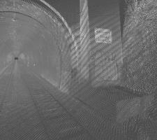
Advances in LiDAR are helping transport authorities improve services and identify potential problem areas, as geospatial technology expert Dr Neil Slatcher explains.
The effects of climate change on the transport infrastructure have long been a cause of concern within the transportation sector - and not only on the structures themselves but also on the surrounding areas. This year, those concerns have become reality with landslides, structural collapses and surfacing issues impacting services across the world.
Traditionally, the identification and monitoring of problem areas has been very labour-intensive – effectively dispatching a surveyor to site - but now the sophisticated use of laser technology can help recognise unstable situations that are the precursor to such rapid and catastrophic failures. With problems of inaccessibility, the rail industry stands to benefit most from using this technology and a recent landslip in the UK is a prime example.
Two people were injured when two trains collided after torrential rain caused a landslide near Watford Junction. While the line owner,
Advances in technology now allow transport authorities to observe changes in the landscape in 3D. Incorporating light detection and ranging (LiDAR) systems allows potential issues to be detected early and technical intervention teams to be deployed before an incident occurs or to quickly assess the damage, enabling restitution work to be carried out more quickly and efficiently.
Traditionally, surveying rail infrastructure has relied on using in-situ sensors to monitor areas known to be unstable but this method only works on problem areas already identified. A mobile scanning unit attached to a train or backpack provides a comprehensive scan, capturing everything in the path and allowing for scrutiny of an entire track or network. This extends beyond the track and sleepers to the surrounding infrastructure and landscape. A single pass with a LiDAR scanner can often be enough to highlight future problems, from obvious obstacles on a line to deeper cracks in critical infrastructure.
Recent advances in mobile laser scanning mean up to tens of kilometres a day can be captured by one scanning unit. By combining a high accuracy survey-grade inertial navigation system and two LiDAR scanner heads, each measuring 550,000 points per second, the technology captures an extremely high-resolution dataset with achievable accuracies within 10-20mm.
LiDAR systems will comfortably operate at speeds of around 100km/hr, though too fast can make the resulting pointcloud less dense than is ideal for monitoring purposes. Rail operators set the speeds at which trains can travel on their lines so it can often be easier to carry out scans at night, once passenger trains have ended for the day, when a consistent speed of around 50km/h can be maintained.
In France, engineering company Groupe Fit Esic uses 3D mapping technology to survey hundreds of kilometres of the French rail network for operator
The data provided allows for retrospective analysis including stability checks, infrastructure inventories and clearance analysis as well as identifying and prioritising maintenance needs. This process helps surveyors and engineers to identify unstable embankments and ground disturbance caused by vibrations of passing trains and weather conditions by showing abnormal curvatures, fissures and physical masses. Often, such changes are obvious (not requiring comparison to previous data) though with mobile mapping technology now more accessible, best practice can include regular monitoring to check for changes over time. LiDAR monitoring is particularly useful in areas prone to landslides, rockfall and debris flow where even subtle changes can show a pattern of degradation over time.
This type of technology also increases the safety and efficiency of survey personnel. In comparison to static terrestrial laser scanners, the train/vehicle/backpack-mounted mobile laser scanners allow automated scans to be completed without dedicating a large team to the job. This reduces staffing costs, freeing team members to work on other projects.
Groupe Fit Esic has been reported as saying that its 3D mobile mapping technology significantly reduces time-to-delivery of surveying projects. Other reports suggest that mobile laser scanning allows projects to be carried out up to 80% faster when using terrestrial scanners. Pre-construction specialist, Central Alliance, operates emergency response teams on major landslide sites across the UK’s railway network and has recently acquired a universal MLS (Mobile Laser Scanner) known as Robin.
In such emergency work, getting an accurate representation of geomorphological features to assess slope stability is key but acquiring data in these difficult-to-access locations (which pose a severe safety risk) is challenging, so LiDAR’s ability to gather data quickly and accurately is invaluable. Data can be collected via a wearable system mounted on a backpack or airborne using UAVs and helicopters in areas impassable on foot. “When making assessments on a failing slope, we need to know exact information about the existing condition so we can assess how it has failed and how to tackle this in remediation,” says Richard Pidcock, technical director at Central Alliance. “It helps immensely in this situation to have a detailed 3D model of the site which we can obtain using Robin.”
Such systems not only help assess areas when an incident occurs, they can also be used to calculate the risk of catastrophic failures in certain area.
On the road
The use of LiDAR has increased dramatically over the last 18 months with laser scanners being used in the development of autonomous vehicles. When positioned on the top of a car, these small units can scan around 60m in all directions, producing an accurate 3D map of a vehicle’s surroundings. A small LiDAR scanner mounted in a self-drive vehicle helps it navigate obstacles in real-time but for driverless vehicles to operate correctly, each city and highway will need to be mapped in great detail, including road markings, barriers, traffic lights and street furniture. These maps will be merged with speed restrictions and traffic management system data.Companies like Uber and Google are creating these interactive 3D models which will enable different stakeholders to access the layers of information including road and rail assets, vegetation growth, road markings and bridge clearances.
One US city council had budgeted around $1m to employ a team of engineering students to evaluate its pavements and street furniture by walking the route and evaluating the damage by sight. This process would take around a year whereas, by using LiDAR, the scan and data processing would be complete in less than a month – including detailed visualisations to assist with monitoring high traffic areas most in need of regular maintenance. And, although any roadworks cause delays, unplanned works offer little opportunity to implement diversions or countermeasures, pre-position materials and equipment or to pre-fabricate solutions.
Lithuania’s Road & Transport Research Institute (known as KTTI) is using LiDAR-derived mapping software to keep on top of physical changes, such as surface deterioration, on their highways and to plan works accordingly. It is using LiDAR to monitor roads and help produce ‘black-spot’ maps and inform studies highlighting incident prevention.
In the Netherlands, engineering company Geomaat was seeking to improve the safety, accuracy and speed of its road surveying work and invested in a LiDar-based StreetMapper system. This can be attached to any vehicle and perform scans at normal speeds on open roads. Geomaat then developed bespoke post-processing software to automatically identify the white lines and barriers on the roads and also round -shaped objects, all visible on the resulting pointcloud.
This system has been used on projects including
According to Geomaat, this solution provides the data at half the cost of traditional surveying methods while reduced night work meant overtime savings. And as the system is vehicle-mounted, workers are protected from both moving traffic and the weather while road users’ inconvenience is reduced by eliminating road closures. Furthermore, the accuracy of the end data has greatly improved because it is presented in both absolute and relative terms.
So LiDAR technology really can help provide highly accurate data across all types of transportation systems.
About the author: Dr. Neil Slatcher is research and development manager at geospatial technology specialist


