With US highways constantly carrying larger volumes of traffic, state and local departments of transportation (DOTs) face an ever-increasing challenge to reduce the impacts of construction and maintenance work zones on traffic congestion. According to the Texas A&M Transportation Institute’s December 2012 Urban Mobility Report, the total financial cost of congestion in fuel and delays in 2011 was US$121bn.
Estimates by the US
The growing problem is driving a boom in research activity by the FHWA and US universities, with an increasing focus on issues such as driver behaviour and car following. A recent study by the University of Iowa highlights a knowledge gap in the area of erratic acceleration and deceleration in work zones and the attendant risk of rear-end collisions.
It also points out (from the results of a driving simulator experiment) that, if drivers are uncomfortable driving at a posted work zone speed limit, they will go slower. This can result in large deceleration rates and an increased crash risk for upstream drivers expecting to travel through at the posted limit.
The most ambitious exercise currently under way is an FHWA study on the Calibration of Driver Behaviour Parameters for Optimization of Work Zone Throughput. Research is being undertaken at FHWA’s Turner-Fairbank Highway Research Center in McLean, Virginia, and at the University of Central Florida in Orlando, Florida. They are putting driver behaviour under the microscope to generate the detailed data needed for more accurate and effective modelling and simulation of traffic flows at freeway work zones.
Taylor Lochrane, a research civil engineer in the FHWA’s Office of Operations Research and Development and lead author of a progress report on the project, says: “Traffic engineers use a variety of analytical tools such as modelling and simulation to better understand the effects that work zones have on traffic, and selecting the right one to perform the analysis is important”. When a low volume of input data is available, the report suggests, engineers can use resources such as the TRB’s Highway Capacity Manual, QuickZone, Quewz software (see panel) and impact analysis spreadsheets developed by individual states.
But, for more complex projects needing more detailed analyses, and to test and fully evaluate operational strategies that might help reduce congestion in work zones, they need to turn to micro simulation. This makes possible the modelling of individual vehicle movements on the second or sub-second basis needed for accurate assessments of traffic flows and forecasts of traffic conditions.
When large volume of data input are going to be necessary the progress report references the relevance of available micro-simulation software programs such as
Virtual
Micro simulation models equip engineers with a realistic virtual environment for testing new traffic management strategies for work zones. But, the FHWA report warns that calibrating such detailed models is a challenge because changes in driver behaviour both approaching and in work zones are not fully understood and hence the drive for more research.
Says Lochrane: “Currently, work zone capacity is not a direct input in simulation models, which use the same assumptions for car-following behaviour on the normal freeway conditions as they do in a freeway work zone. My hypothesis is that drivers change their behaviour in a zone.
“This will ultimately lead to disruptions in traffic flow that may not be captured in simulation if the behaviour is not represented. By adjusting car-following thresholds in the model, engineers will be able to model freeway work zones more accurately to provide improved guidance on their impact.”
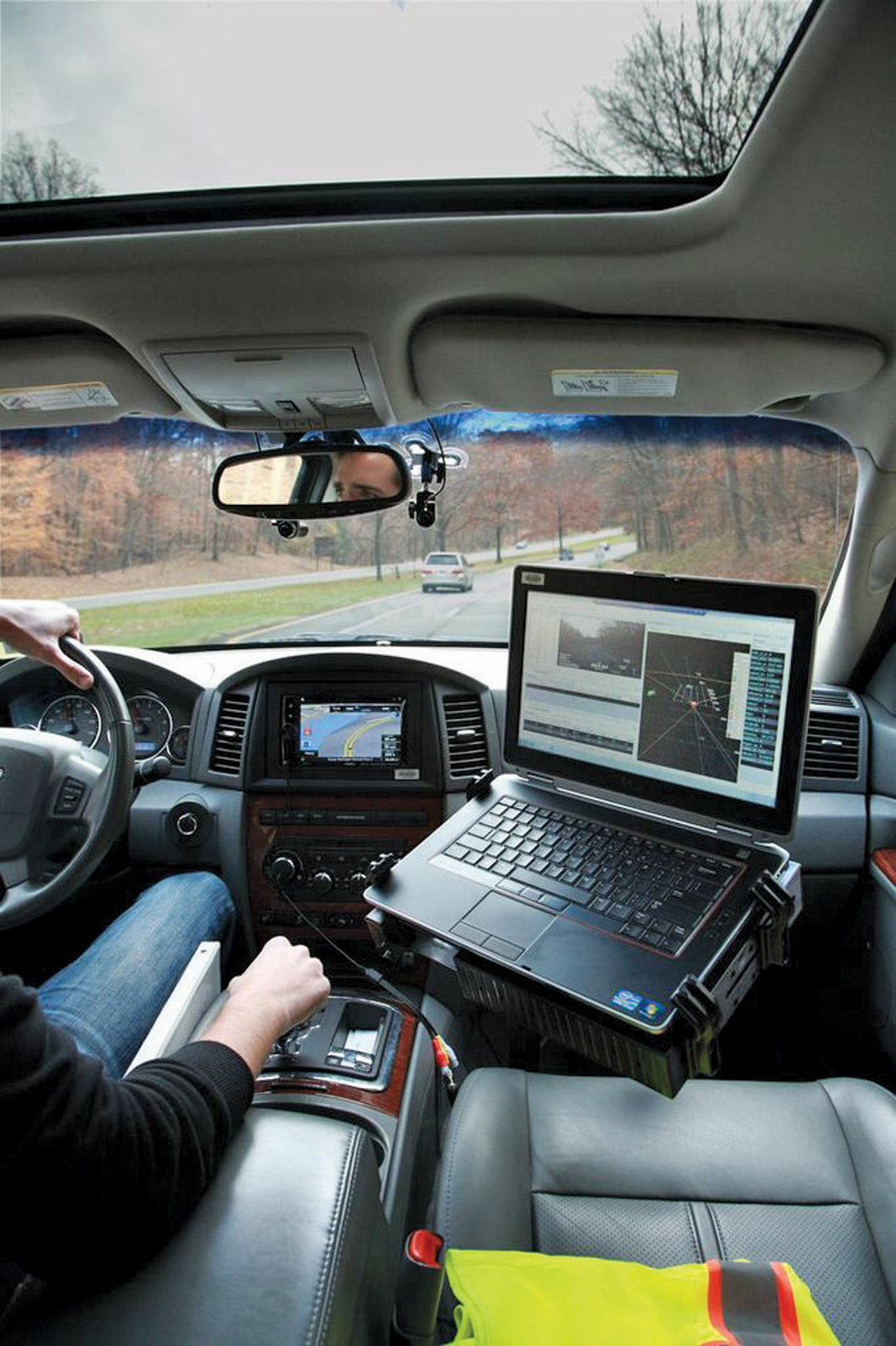
So for the current FHWA study, researchers have designed an experiment to capture data on work zone changes in driver behaviour. They are using an instrumented research vehicle (IRV) to monitor the gaps between vehicles and also their oscillations (ie the variations in gaps resulting from the accelerating and braking movements that a driver makes when following another vehicle).
Inside the vehicle the researchers have built a dedicated connected mobile traffic sensing (CMTS) array, integrating a range of commercially-off-the-shelf (COTS) ITS equipment to give real-time work zone traffic data. This includes two front and rear medium-range radars, from German company smartmicro, which are mounted behind standard plastic bumpers to avoid alerting other drivers and causing them to alter their behaviour. These work together with an onboard GPS-based speed sensor, from UK company RaceLogic, to log the relative speeds of, and distances between, the vehicles in front of and behind the IRV. Bluetooth sensors estimate travel time and an onboard computer stores all the data.
Other onboard equipment logs work zone activity collected from forward- and rear-facing video cameras mounted inside the vehicle. The video footage helps the researchers to put the radar data in context and identify activities such as lane changing that is going on around the IRV. “It is important to know what is going on in the work zone to understand better the conditions that we are trying to model,” says Lochrane.
Living laboratory
In February 2013, 64 volunteers began driving the IRV through a ‘living laboratory’ real-world work zone set up along a 4.8km stretch of Interstate highway (I)–95 in Virginia. Before they started the experiment was described to participants without mentioning the term ‘work zone’ lest it skew their behaviour.
The FHWA’s report notes that the results of a questionnaire accompanying the project shows that researchers were justified in their initial assumption that car-following, and not lane changing, would be the main influence on throughput and capacity. The results show that 57% of drivers stayed in the same lane through a work zone and matched their speed to that of the vehicle ahead.
The report says ‘Maintaining the speed and distance from the car in front is the unconscious car-following behaviour that the instrumented vehicle sought to capture’. Responses from drivers also confirmed that they tend to drive more slowly and cautiously entering work zones with a temporary concrete barrier to their left.
Says Lochrane: “What this shows is that drivers have different comfort levels when driving through freeway work zones, as well as different levels of risk. Some drivers might follow the vehicle in front more closely (which might be considered risky) while others might leave more space between them (which might be considered less risky). But changes in behaviour impact the throughput and capacity of the zone.
“I would not characterise either behaviour as good or bad but as examples of the naturalistic way in which drivers behave. We need to understand this behaviour so we can better design and plan for work zone deployments, for the safety of the driver and workers as well as for optimising throughput.”
In the next phase, the researchers plan to investigate the gap that each driver maintains on the freeway before, during, and after passing through the work zone. They also will test the development of threshold values for a psycho-physical car-following gap model, using micro simulation techniques, with the aim of publishing the results by end-2013.
On the potential safety implications of the research, Lochrane says: “Our current study is focussing on mobility, but all the data will be made available for future researchers for safety studies. Understanding the car-following characteristics of different drivers through a freeway work zone will help us appreciate their comfort levels and the risks they take. ITS-based as well as physical work zone markers also form definite parts of the FHWA’s ongoing plans to help protect drivers and their passengers.”
Low input data volume resources
The fifth edition of the US
Developed within the FHWA’s Research, Development and Technology programme, QuickZone offers a method of comparing the traffic impacts of alternative work zone mitigation strategies and can be used to estimate the resulting costs, delays and risks of traffic backups. As one example, when an agency is planning shoulder widening, the product can compare the costs of carrying out the work at night-time rather than in the day; or of traffic diversions onto one road rather than another during successive construction stages. It is also designed to evaluate the comparative advantages of retiming traffic signals on diversionary routes to smooth flows, or of using traveller information systems.
QUEWZ is a microcomputer-based analytical tool developed by the FHWA-established Center for Microcomputers in Transportation (McTrans) at the University of Florida to support the planning and scheduling of lane closures in freeway work zones. It can compare traffic conditions on a given road segment with and without lane closure and estimate the additional road user costs (including those of travel time and vehicle operation) of a closure.
CORSIM
McTrans’s CORSIM (CORridor-microscopic SIMulation program) has “been used to model work zones by taking advantage of high-occupancy vehicle (HOV) lane and incident features,” says the Center’s Dr David K Hale. The program has the ability to classify HOV lanes as ‘closed to all traffic’ and incidents as causing ‘blockage at point of incident’ in any given time periods. It also has a calibration setting for the location of an incident warning sign.
When field data was unavailable for a research project set up to evaluate arterial work zones, CORSIM was used to develop specific configurations and to obtain relationships between relevant factors and work zone capacity. This was estimated as a function of factors including the percentage of left-turning vehicles and the distance of the work zone from the downstream intersection.
Psycho-physical
A psycho-physical model is one that incorporates drivers’ perceptions (what they see and sense) as a factor in the car-following process. German research has revealed that human driving behaviour is naturally distributed with individuals having different driving, perception and estimation abilities Each has different safety needs, speeds at which they are comfortable and acceleration/deceleration characteristics.
The model takes account of defined, distinct phases in the car-following process. For example, as a driver approaches close to a vehicle in front, they will start to brake in order that they don’t run into it. Each driver will have their own threshold for when to apply the brake, depending on their perception of the closeness of the vehicle in front.
Then, as they perceive that their vehicle is starting to separate from the one in front, they will press the accelerator in order to catch up – resulting in what is referred to as an unconscious speed oscillation.
S-Paramics
Developed by SIAS subsidiary Paramics Microsimulation, S-Paramics software is being used in a research project funded under the Scottish Road Research Board’s 2012-2013 research programme. This aims to achieve a better understanding of the operational impacts of driver behaviour on the approach to road works to enable practitioners to develop safer and more effective traffic management regimes.
Malcolm Calvert from SIAS says: “It is clear that, while the layout of many traffic management configurations at road works does not dramatically differ from the ‘normal’ merging of two lanes into one, the throughput observed can differ dramatically. Yet despite the very great impact this can have on capacity, delays, safety and emissions, the reasons for this are not well understood.
“In order accurately to model roadworks, it is critical to have an understanding of how driver behaviour [in road works] may differ from that in ‘normal’ circumstances.” The research will include a review of case studies to identify the discrepancies that exist between modelled and observed driver behaviour. In evaluating the interface between the driver and the road environment and between the driver and other road-users, the study will examine the relationship between the observed behaviour and the academic knowledge base in the area of human sciences. The outcomes will include recommendations for modelling driver behaviour at road works and some initial ideas on how positively influence driver behaviour to improve traffic conditions.
Quadstone Paramics
Some parts of New Jersey’s Route 139 date from the 1920s and need total renewal. The route is a key connection between the north of the State, Jersey City’s waterfront and the Holland Tunnel which links the State to Lower Manhattan in New York. It consists of a two tiered roadway with the upper being signalised and a lower having controlled-access. Both levels are connected with surface streets and the tunnel via bi-directional viaducts.
Around 80,000 vehicles use it each weekday, keeping it at or nearly at capacity for much of the day. Its regional importance predicated the minimising of road works through a multi-phased construction programme, each phase creating its own impacts and demanding specific mitigation methods.
New Jersey chose Quadstone Paramics to simulate solutions including time-of-day lane closures, reversible lanes, traffic detours, adaptive signal controls, and police direction of traffic as well as the likely effects of incidents. This process provided criteria for the elimination or implementation of individual strategies and the company says the visualisation capability added a fresh level of understanding of the consequences of each option.
On-the fly network editing also allowed for visual ‘what-if’ testing of changes to signal timings, signal phasing, and detour options at project meetings.
Vissim
Developed by German company
Leonhardt agrees with the FHWA report that calibration of detailed models can be a challenge. “If, due to cost and time pressures, project managers and engineers need to make savings, it is the calibration that tends to suffer. Without this, simulation will still give results, but they will not be as good,” he says.
He accepts that, realistically, it is not always possible to perform field measurements, although this is ideal, and points out that engineers can take advantage of experience from elsewhere. “There is, for example, a good deal of technical literature available on deployments and that will at least give them some starting points for modelling.” He goes on to suggest that driver information/assistance technologies, and emerging cooperative vehicle systems (car2Car/car2infrastructure communications), “can also improve traffic efficiency and safety at work zones. Microscopic simulation is an excellent methodology for designing and assessing them”.
Aimsun
Traffic management during the construction of a new water tunnel close to the Queensboro Bridge in New York City involved a contraflow on the bridge approach, street closures and a detour route. These diversionary plans were evaluated before implementation. The US$210,000 project for the
Field conditions posed several challenges in developing the simulation model. Among these, several intersections on the bridge approach have traffic enforcement agents to prevent gridlock and when conditions permit, advance vehicles can override signal settings and alter vehicle discharge characteristics.
The solution involved:
• Use of Aimsun’s ‘sunshine control’ or ‘yellow box’ feature in the simulation model to avoid gridlock, by preventing vehicles entering an intersection unless gaps were long enough to allow them to clear it
• Adjustment of vehicle behaviour parameters inside the ‘yellow box’ to reflect field discharge rates at stop lines.
One bonus was that 66 days of continuous volume data for the bridge was available for the analysis making it possible to reliably identify the bridge’s capacity.
Aside from calibration issues, the turning radii of large trucks and buses detouring to the contraflow required special attention using AutoTURN turn simulation and AutoCAD computer aided design software. When larger vehicles were seen to use the middle of three lanes on 58th Street to enter the contraflow, the stop lines were adjusted to accommodate them. The combined solution was of material help in finalising the operating configurations for the MPT plan - specifically the contraflow element. The project has received an American Council of Engineering Companies (ACEC) national recognition award.


