David McGowan
David Crawford looks at technologies for better emergency medical service delivery.
Emergency medical services (EMS) play key roles in transporting, or bringing treatment to, patients who become ill through medical emergencies or are injured in road traffic accidents (RTAs). But awareness has been rising steadily, in the US and elsewhere, of the extent to which EMS can generate their own emergencies. The most common cause is vehicles causing or becoming involved in RTAs, as a result of driving fast under pressure to meet rapid response targets.
At the same time, growing traffic congestion is highlighting the need for better routeing information and technology, to speed up critical response and treatment times. This is vital to avoid unnecessary delays caused by vehicles being, for example, routed by standard practice across a bridge that has been temporarily closed.
The US experiences over 6000 ambulance crashes a year, and these account for 74% of the deaths in service of EMS personnel, with driver behaviour as a major cause. Apart from the loss of life, “the associated costs can cripple an agency for years”, says ambulance safety consultant David McGowan, who has recently set up7710 Fleet Safety Solutions to advise providers on accident reduction programmes.
He puts the sector’s total loss at over US$800 million a year; “this is an epidemic that the US needs to take action on. Not all cases are urgent enough to need the full-scale ‘lights and sirens’ response, with ambulances driven as fast as possible to save a few minutes”.
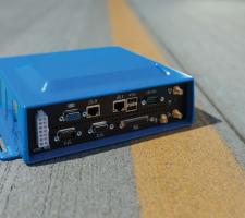
The human and financial Toll is spurring growing interest is technologies that can monitor and modify driver behaviour. Among these is the RescueNet Road Safety ‘black box’ developed by Massachusetts, US-based Zoll Medical Corporation, to which McGowan is a consultant.
The GPS-enabled onboard computer is configured to capture location-based data along with factors including speed, turn signals, braking, acceleration and deceleration, G forces, use of emergency lights and sirens, seatbelt status and vehicle diagnostics. Each EMS management can decide on safe limits and set appropriate parameters through their own web-based administration.
Drivers are identified by log-in keys. When on the road the system sounds an audible alert sounds in the vehicle if the driver is approaching a safety limit and this will intensify until corrective action is taken. Management can receive immediate violation alerts (by email or text), access critical reports and analyse overall driver performance through the system’s web-accessible safety dashboard, to evaluate behaviour and assess specific training needs.
McGowan says one EMS provider’s ambulance crash record fell from one or two per month before the installation to a single accident in the 16-month period following. Safety benefits aside, the company says the system typically pays for itself within two years due to improved fuel economy, reduced maintenance costs and extended vehicle life.
Fort Worth, Texas, is one of 160 places in the US where the local EMS provider (in this case MedStar) is deploying Mobile Area Routing and Vehicle Location Information System (MARVLIS) technology. Developed by South Carolina-based GIS solution specialist Bradshaw Consulting Services, the system combines GPS positioning with traffic modeling to help ambulance crews better to navigate typically heavily-trafficked roads over an area exceeding 1,000km2.
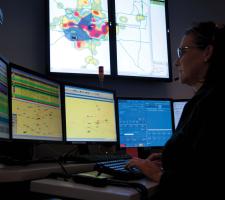
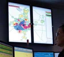
Not only does the system route ambulances around construction and congestion hold-ups it also predicts which areas are likely to generate emergency calls over the next hour. This demand monitor mode uses historic data to generate a ‘weather map’ showing the likelihood of a call coming in over the next hour from a given area. This map is updated every few minutes, creating the effect of a weather front on the move.
The resulting hot zones identify a 10%-15% sector of the territory which typically generate up to 80% of the next hour’s incoming calls. This allowing call centre supervisors to pre-position ambulances within reasonable proximity of anticipated needs.
In response to EMS providers’ requests, Bradshaw Consulting is currently developing a ‘move up’ enhancement to make pre-positioning more dynamic in response to fluctuating levels of ambulance availability. The firm’s Dale Loberger told ITS International: “By decreasing the distance needing to be travelled, vehicles do not have to move at unsafe speeds to meet response time standards”.
In New Mexico, the Albuquerque Ambulance Service has recently installed7708 Zoll’s RescueNet Dispatch Pro software to help its staff predict where ambulances should be positioned at any given time. The technology adds predictive capability to the company’s RescueNet Dispatch (which the Albuquerque Ambulance had already acquired) and enables dispatchers to access hot zone maps reflecting up to five years’ experience of vehicle deployment when, for instance, handling major events.
Before the installation, ambulances were responding to life-threatening calls within 10 minutes between 86% and 88% of the time; subsequently, says the company, that rate has exceeded 96%.
To complement the new technology, department heads gather for daily PULSE (performance/utilisation/late response/system analysis/exceptions, events and excellence) meetings. These meetings use system data to examine performance and are open to the public. The Service sees the idea (developed from an initiative in Pinellas County, Florida, which uses the same software) as enabling it to create a ‘continuous learning environment’.
According to Zoll, about 500 ambulance companies and firefighting units around the US currently use RescueNet Dispatch, 82 of which have the RescueNet Dispatch Pro feature.
Both Zoll and Bradshaw offer journey-specific components that use automatic vehicle location (AVL) data to learn traffic patterns and make closest-vehicle and best-route recommendations, which are automatically updated to reflect changing conditions or times of day.
But much remains to be done says Dr Nadine Levick, a New York-based practising EMS medic who is the founder and CEO of the EMS Safety Foundation, and lectures globally on accident avoidance. In the US, she says, there are more safety standards for moving cattle than for transporting patients and “ambulances can be the most lethal vehicles on the road.”
Dr Levick highlights the findings of limited research which suggest that EMS transportation safety is in need of urgent focus. “It is unique gap in the standards, oversight and coordination of the transport system as a whole,” she says.
Currently she is working to persuade the US Federal Motor Carrier Agency to extend its regulatory scope from commercial vehicles and buses into the health sector. In ITS terms, she is interested in the scope for fleet management (FM)-oriented apps for in-vehicle handheld devices that could act as data capture tools for enhancing ambulance deployment.
This is an area of emerging interest to UK-based FM specialist7709 Telematicus, which also operates in the US, Canada and Brazil. Previously it had focused on safe driving software solutions for major commercial users although its system had achieved a 10% fuel saving in 50-strong Nationwide fleet of mobile carers who support families with a child suffering from a life threatening or terminal illness.
“We’re keen to be in EMS”, CEO Simon Ralphs told ITS International. Once connected to a smartphone or similar device, the company’s Global Green Drivers product feeds GPS- and accelerometer-derived data back to the FM system.
The basic-level version is designed to save operators the cost of installing additional in-vehicle hardware and can capture speed, harsh braking/acceleration/cornering and reversing data. An enhanced version plugs into the vehicle’s on-board diagnostics port.
The system can also, says Ralphs, “stop phone calls and texting in-trip as a safety measure” – a point to which Levick attaches high importance. Meanwhile, she is looking forward to the January 2014 annual meeting of the US Transportation Research Board and the publication of the 2012-2014 Moving Ahead for Progress in the 21st Century (MAP-21) surface transport funding and authorisation Act
There she hopes to find potential to “create an environment to facilitate knowledge transfer between transport and highway safety and EMS practitioners".
EMS Safety Foundation
The7711 EMS Safety Foundation is a not-for-profit international and multidisciplinary virtual think tank which was set up to fill perceived gaps in technical knowledge transfer, practical R&D and system evaluation within EMS and medical transport generally.
Emergency medical services (EMS) play key roles in transporting, or bringing treatment to, patients who become ill through medical emergencies or are injured in road traffic accidents (RTAs). But awareness has been rising steadily, in the US and elsewhere, of the extent to which EMS can generate their own emergencies. The most common cause is vehicles causing or becoming involved in RTAs, as a result of driving fast under pressure to meet rapid response targets.
At the same time, growing traffic congestion is highlighting the need for better routeing information and technology, to speed up critical response and treatment times. This is vital to avoid unnecessary delays caused by vehicles being, for example, routed by standard practice across a bridge that has been temporarily closed.
The US experiences over 6000 ambulance crashes a year, and these account for 74% of the deaths in service of EMS personnel, with driver behaviour as a major cause. Apart from the loss of life, “the associated costs can cripple an agency for years”, says ambulance safety consultant David McGowan, who has recently set up
He puts the sector’s total loss at over US$800 million a year; “this is an epidemic that the US needs to take action on. Not all cases are urgent enough to need the full-scale ‘lights and sirens’ response, with ambulances driven as fast as possible to save a few minutes”.
The human and financial Toll is spurring growing interest is technologies that can monitor and modify driver behaviour. Among these is the RescueNet Road Safety ‘black box’ developed by Massachusetts, US-based Zoll Medical Corporation, to which McGowan is a consultant.
The GPS-enabled onboard computer is configured to capture location-based data along with factors including speed, turn signals, braking, acceleration and deceleration, G forces, use of emergency lights and sirens, seatbelt status and vehicle diagnostics. Each EMS management can decide on safe limits and set appropriate parameters through their own web-based administration.
Drivers are identified by log-in keys. When on the road the system sounds an audible alert sounds in the vehicle if the driver is approaching a safety limit and this will intensify until corrective action is taken. Management can receive immediate violation alerts (by email or text), access critical reports and analyse overall driver performance through the system’s web-accessible safety dashboard, to evaluate behaviour and assess specific training needs.
McGowan says one EMS provider’s ambulance crash record fell from one or two per month before the installation to a single accident in the 16-month period following. Safety benefits aside, the company says the system typically pays for itself within two years due to improved fuel economy, reduced maintenance costs and extended vehicle life.
Routeing
Fort Worth, Texas, is one of 160 places in the US where the local EMS provider (in this case MedStar) is deploying Mobile Area Routing and Vehicle Location Information System (MARVLIS) technology. Developed by South Carolina-based GIS solution specialist Bradshaw Consulting Services, the system combines GPS positioning with traffic modeling to help ambulance crews better to navigate typically heavily-trafficked roads over an area exceeding 1,000km2.
Not only does the system route ambulances around construction and congestion hold-ups it also predicts which areas are likely to generate emergency calls over the next hour. This demand monitor mode uses historic data to generate a ‘weather map’ showing the likelihood of a call coming in over the next hour from a given area. This map is updated every few minutes, creating the effect of a weather front on the move.
The resulting hot zones identify a 10%-15% sector of the territory which typically generate up to 80% of the next hour’s incoming calls. This allowing call centre supervisors to pre-position ambulances within reasonable proximity of anticipated needs.
In response to EMS providers’ requests, Bradshaw Consulting is currently developing a ‘move up’ enhancement to make pre-positioning more dynamic in response to fluctuating levels of ambulance availability. The firm’s Dale Loberger told ITS International: “By decreasing the distance needing to be travelled, vehicles do not have to move at unsafe speeds to meet response time standards”.
In New Mexico, the Albuquerque Ambulance Service has recently installed
Before the installation, ambulances were responding to life-threatening calls within 10 minutes between 86% and 88% of the time; subsequently, says the company, that rate has exceeded 96%.
To complement the new technology, department heads gather for daily PULSE (performance/utilisation/late response/system analysis/exceptions, events and excellence) meetings. These meetings use system data to examine performance and are open to the public. The Service sees the idea (developed from an initiative in Pinellas County, Florida, which uses the same software) as enabling it to create a ‘continuous learning environment’.
According to Zoll, about 500 ambulance companies and firefighting units around the US currently use RescueNet Dispatch, 82 of which have the RescueNet Dispatch Pro feature.
Both Zoll and Bradshaw offer journey-specific components that use automatic vehicle location (AVL) data to learn traffic patterns and make closest-vehicle and best-route recommendations, which are automatically updated to reflect changing conditions or times of day.
More work needed
But much remains to be done says Dr Nadine Levick, a New York-based practising EMS medic who is the founder and CEO of the EMS Safety Foundation, and lectures globally on accident avoidance. In the US, she says, there are more safety standards for moving cattle than for transporting patients and “ambulances can be the most lethal vehicles on the road.”
Dr Levick highlights the findings of limited research which suggest that EMS transportation safety is in need of urgent focus. “It is unique gap in the standards, oversight and coordination of the transport system as a whole,” she says.
Currently she is working to persuade the US Federal Motor Carrier Agency to extend its regulatory scope from commercial vehicles and buses into the health sector. In ITS terms, she is interested in the scope for fleet management (FM)-oriented apps for in-vehicle handheld devices that could act as data capture tools for enhancing ambulance deployment.
This is an area of emerging interest to UK-based FM specialist
“We’re keen to be in EMS”, CEO Simon Ralphs told ITS International. Once connected to a smartphone or similar device, the company’s Global Green Drivers product feeds GPS- and accelerometer-derived data back to the FM system.
The basic-level version is designed to save operators the cost of installing additional in-vehicle hardware and can capture speed, harsh braking/acceleration/cornering and reversing data. An enhanced version plugs into the vehicle’s on-board diagnostics port.
The system can also, says Ralphs, “stop phone calls and texting in-trip as a safety measure” – a point to which Levick attaches high importance. Meanwhile, she is looking forward to the January 2014 annual meeting of the US Transportation Research Board and the publication of the 2012-2014 Moving Ahead for Progress in the 21st Century (MAP-21) surface transport funding and authorisation Act
There she hopes to find potential to “create an environment to facilitate knowledge transfer between transport and highway safety and EMS practitioners".
EMS Safety Foundation
The


