Combining accurate network estimates and forecasts with real-time information is the way to deal with traffic hot spots. Alan Dron looks at products which aim to achieve just that
Traffic management authorities have for years been trying to get ahead of the game. Instead of reacting to situations, they want to be able to head them off as they occur – or even before they happen. Finding that Holy Grail of successfully anticipating problems will save time, tension and tempers on city streets.
Two new systems with that aim in mind have been developed to provide such solutions for traffic managers, by combining the capabilities of multiple components and producing solutions that are greater than the sum of their parts. One has already been deployed, while the other is awaiting its first customer.
Congested city
The deployed system, from
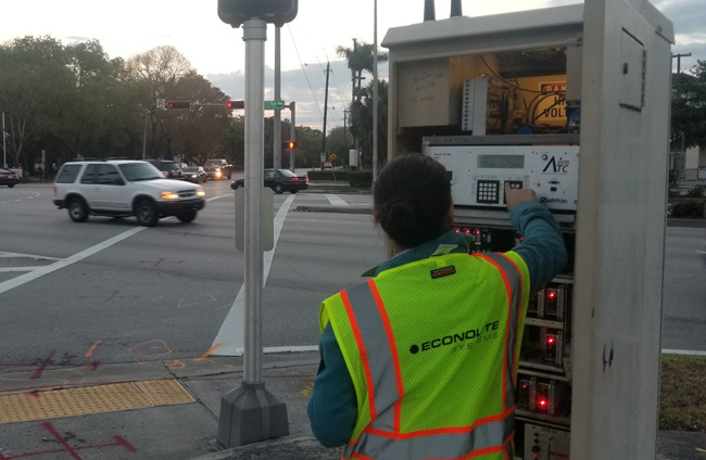
In an effort to cut congestion in the NW36th Street corridor in Doral, Miami-Dade County, the Information Technology Department and Department of Transportation and Public Works decided to expand the county’s traffic mobility management programme in 2016 by implementing a small-scale Adaptive Signal Control Technology solution, under which Econolite installed its adaptive signal control technology upgrade at 10 intersections.
Precise measurement
The NW36th Street corridor incorporated a combination of Econolite signal controllers, detection sensors, its Centracs advanced traffic management system (ATMS) software with adaptive signal control and a Bluetooth-based travel time system that precisely measures traffic performance.
The upgrade included adaptive functionality and video detectors placed at intersections to evaluate traffic per lane. Additionally, the controllers allow for real-time traffic movement decisions based on the actual traffic patterns and to make use of other traffic detectors already installed at those intersections. This was the first of 12 corridors in the county to receive Econolite’s ITS technologies and smart traffic signals. Some 300 intersections are receiving the new signals.
“The NW36th Street corridor is a major corridor that serves a high volume of commuter and commercial traffic, as it is very close to Miami International Airport,” said an Econolite spokesman. “The Centracs Adaptive system leverages traffic data from multiple sources to continually adapt signal timing to traffic conditions.”
The Centracs ATMS supports connected vehicle applications, he added. “The deployment includes equipment that has additional processing capabilities to handle advanced applications such as those for connected vehicles. Miami-Dade County wanted, and is getting, a very ‘future-proof’ traffic infrastructure that immediately mitigates the congestion challenges of the county, while providing a platform for future expansion and connectivity options.”
Future proof
The proof of the pudding, of course, will be the degree to which congestion in the corridor is eased by the new equipment: “Travel time and congestion reduction studies are currently in progress and we hope to publish results soon,” said the spokesman.
Still awaiting its first contract at the time of writing was a collaboration between two German companies – intelligent software provider
Identifying disruption
SMIGHT has been developed from a basic lighting system to one that uses multifunctional base towers that can incorporate facilities such as charging points for electric cars, public Wi-Fi or sensors for recording traffic data and environmental information.
The companies say that the combination of
“The SMIGHT detectors record current traffic situation data, not only the speed but also the number of vehicles passing,” explained PTV Group’s director, traffic software, Peter Möhl.
“This dynamic traffic information collected in real time can be fed into the operative traffic management system PTV Optima. With our software we can then predict short-term into the future and see how traffic will look like, five, 10, 30 minutes ahead.”
The sensors use cloud technology and GSM communication to feed the data into PTV’s software. PTV Visum, the company’s software for traffic analyses, forecasts and GIS-based data management, is used to allow transport planners to create traffic models. The more accurate the data fed into the modelling software, the more precise the traffic model can be and this can help to identify the best ‘hot spots’ at which the sensors should be placed.
Hot spots
“To get accurate models that replicate today’s situation, we compare the typical results from Visum in terms of the [traffic] volume and speed at specific points on the network with real detector data. What is clear is that the more data we can take into account in our planning tools, the easier it is to make sound decisions in the event of current disruptions, or to provide forward-looking analysis for planned events, such as construction sites.”
Historic data collected can be processed in PTV Visum, to assist in strategic transport planning and modelling. Additionally, dynamic traffic information collected in real time via the intelligent street lighting can be fed into the operative traffic management system, PTV Optima. “This reduces the traffic load and enhances quality of life,” said Oliver Deuschle, director at SMIGHT.
“The interplay of PTV and SMIGHT solutions can identify traffic disruptions before they even occur,” added Möhl. “Smart sensor technology, secure data processing and real-time simulation enable cities and municipalities to optimise their traffic flow early on.”
However, although SMIGHT is designed primarily to reduce congestion, its creators regarded the ‘intelligent city’ of which it is designed to be part to have greater virtues than simply a smooth, unbroken flow of traffic. That easing of congestion has the beneficial side effects for residents of making their surroundings more environmentally friendly, more liveable and more connected.
SMIGHT is already being used in cities in Germany, Switzerland, Norway and Australia.
PTV and Optima
PTV Group is placing great store in its Optima system, which it says brings together two previously incompatible data sources to give traffic control room operators new abilities to avoid or mitigate congestion.
Transport modellers have a detailed knowledge of road capacity, plus extensive knowledge of traffic demand because they have collected the data at different times of day; they have a tool that allows them to have accurate network estimates and forecasts. But they do not know what is happening on the road in real time.
Control room operators, meanwhile, know what is happening in real time, but are reactive; they can’t predict the future.
So, how to bring the two sets of knowledge together in a coherent, useful way? PTV says that its Optima system does this, by combining multiple sources of information.
“Essentially, it’s a system that fuses a transport model with real-time data that comes out of fixed loops, Midas loops and devices such as TomTom,” said Devrim Kara, PTV Group director, UK & Ireland. The latter collect data from in-car GPS devices and mobile phone movements.
That combination of data provides operators with frequently updated situation reports that allow them to keep abreast of developing situations. “It allows you to predict the impact of incidents – what would happen to queues in side roads and main roads up to the next half-hour. If you advise drivers to exit a motorway on to side roads, is there enough capacity there? It gives you an analysis of performance in different scenarios. It combines very rich, very detailed transport model with real-time data.”
Equipped with this information, the model can test different scenarios that could be used to mitigate the effects of an accident, such as altering signal settings to create additional capacity on alternative roads on to which traffic would be diverted, or that drivers would naturally choose to avoid the accident and its congestion.


