Transport is the most important of the five domains identified as the pillars of Singapore's far-reaching Smart Nation strategy, launched in November 2014 by prime minister Lee Hsien Loong with the aim of reaching fulfilment by 2024. Roads account for 12% of the island republic's 719km2 land area – just below housing's 14% - a ratio just over four times that of Washington, DC. There are currently over a million vehicles on Singapore's roads - though future growth is being contained by a programme of monthly certificate of entitlement (COE) auctions for intending car and truck buyers.
Available space
The population currently totals over 5.75 million (as compared with Washington's 632,000), and is highly urbanised, with residents living at a density of 8,155 per km2 - the third highest in the world. Numbers continue to grow, prioritising the optimisation of available space. Meanwhile public transit – bus and metro – is under pressure to expand and improve its levels of service delivery. All these factors have coalesced to create a compelling scenario for the emergence of a battery of emerging information and communications technology (ICT) and Internet of Things (IoT)-based technologies. These are taking advantage of the growing availability of low-cost sensors and cloud-based data storage solutions to enable the country to improve the quality of its urban mobility to what its government sees as an acceptable standard. One aim is to deliver detailed insights into the success or otherwise of the island's heavily-used road network in managing traffic congestion and improving bus performance. The country's
Scaleable connectivity
The aim is to deliver an anticipatory style of government that can respond to what will be increasingly data-empowered citizens and businesses. Public agencies (including those in transport) are being encouraged to aggregate their sensor deployment needs and capabilities, and share the results in the interests of the more efficient running of the state. They will tap into both public and commercial telecoms infrastructures to ensure the necessary levels and scalability of connectivity.
Enabling demand
Ong suggested that, among other applications, the resulting networks could enable demand-responsive adjustments being made in real time to bus services, by detecting and communicating the numbers of vehicles plying in a specific area for comparison with desirable service standards. The nodes could also enable communication with, for example, connected cars, to warn drivers of the presence of nearby pedestrians or the approach of emergency vehicles. The next stage upwards in road travel technology - automated vehicles (AVs) - is another application area being given attention. The inaugural issue of GovTech's Smart Nation Snippets e-newsletter highlighted the November 2017 opening, in the Jurong Innovation District, of a dedicated Centre of Excellence for Testing and Research of Autonomous Vehicles (CETRAN). This is designed to simulate genuine road conditions and the impact of the technologies available to deal with them. The publication went on to predict that equipped vehicles will be running on the country's roads by 2022. In one prediction, Ong foresaw smart nodes having roles in supporting on-road navigational beacons. These could guide AVs in, for example, adjusting their travel paths to take them safely through operations falling short of full-scale roadworks – for example, where surface cleaning, tree trimming or verge cutting are under way. CETRAN will also monitor the roles of AVs in contributing, as well as using, IoT-supported data.
Cycling
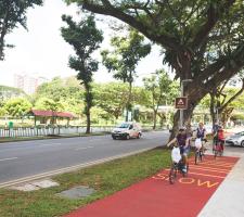
Singapore’s Land Transport Authority is developing what will eventually be a 700km-plus long network of dedicated, distinctively red-painted cycle paths by 2030, in a bid to boost currently low levels of biking take-up. It is starting from the lows of a 1% modal share and a route length of 12km per 100,000 of population. It wants to ensure that most people have safe, direct routes from their homes to public transit hubs from which they can conveniently reach their jobs. In support, the Singapore University of Technology and Design has developed what it claims is an innovative method of monitoring cycle path conditions. This uses riders’ existing smartphones as passive crowd-sourcing sensors, in an economic alternative to fixed equipment such as accelerometers, or labour-intensive physical inspection. The researchers have developed a set of innovative algorithms that can sense rough riding conditions on paths and detect bumps in real time, irrespective of the position of the smartphone on the vehicle or in the rider’s kit. The resulting data will be used to plan timely maintenance programmes. The team has concluded that its solution can successfully be applied to conditions in Singapore.
Joining forces
In the public transit sector, the state's Nanyang Technological University has joined forces with
Data flows
Underlying the new approach is the issue of the capacity of conventional communications networks to cope with the increasing data flows arising from IoT-based deployments, involving potentially billions of devices. In response, Singapore is backing the development of Narrowband IoT systems, which use low-cost, low-power wide area network (LPWAN) radio technology to deliver the levels of connectivity that are going to be needed. Applications being envisaged in addition to maximising the informational roles of widespread on-road node clusters include handling automated fee payments, more efficient parking management - and fuel-saving waste collection routes being tailored to respond to bins signalling that they are ready to be emptied.
Charging
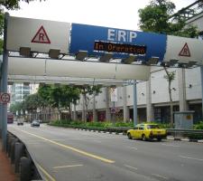
The city state, which pioneered the deployment of urban congestion charging with the 1998 introduction of its dedicated short-range communications (DSRC)-based electronic road pricing system, chose 2016 to announce plans to test a satellite-based alternative which it intends to roll out over 18 months from 2020 at an estimated cost of S$556 million (US$394.9 million). The cost of maintaining the gantries that are currently needed is a key factor, together with the scope for introducing flexible charging reflecting current traffic conditions. The new system will be equipped to update drivers with real-time traffic information and incident alerts derived from connected networks of road-based sensors.


