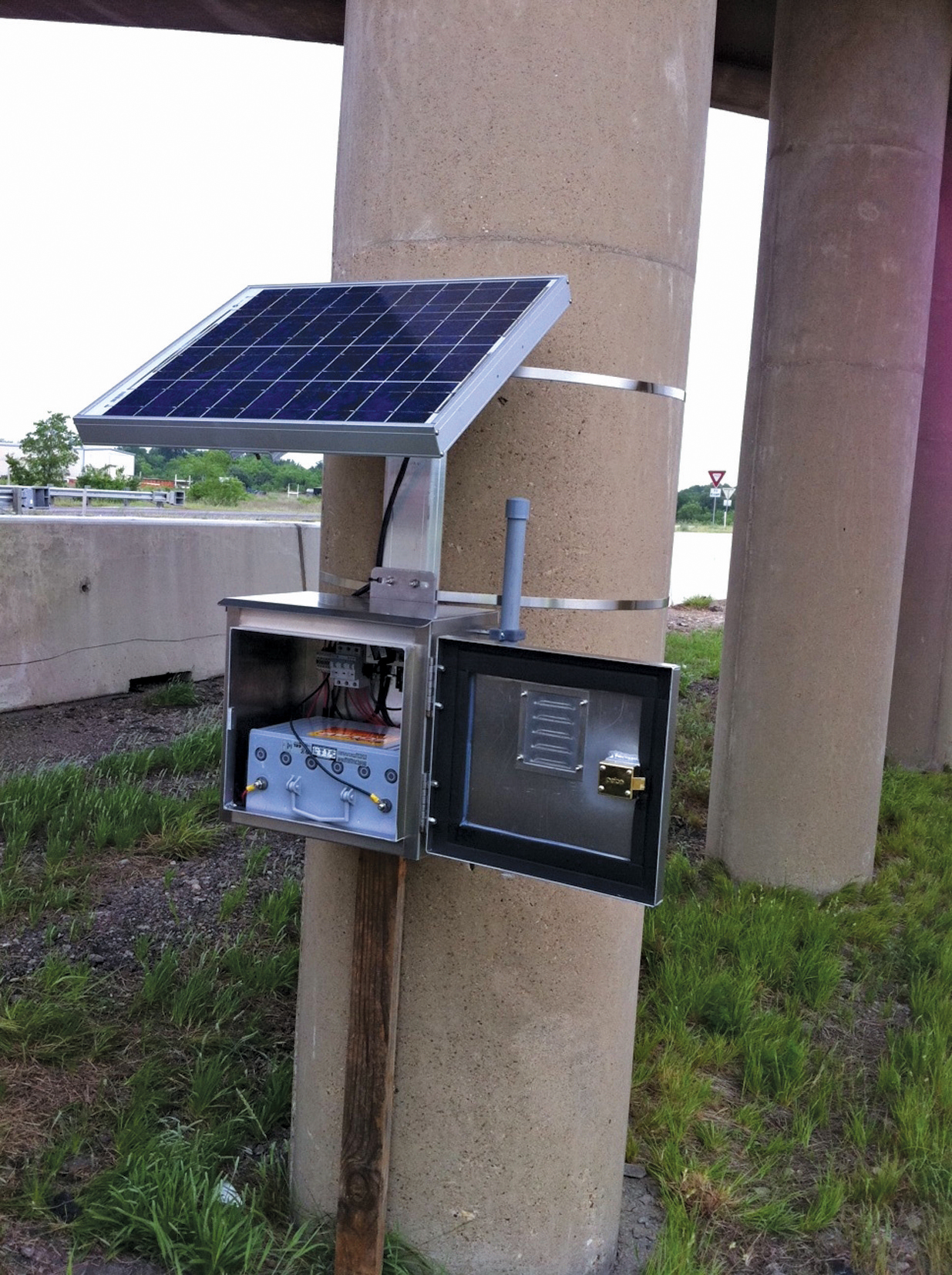
A Bluetooth reader on the I-35
David Crawford reviews developments in temporary ITS.
Widespread take-up of technologies such as Bluetooth and wi-fi are encouraging the emergence of more sophisticated, while still cost effective, ITS responses to the traffic issues posed by temporary road situations such as work zones and special events. Andy Graham of traffic solutions specialists White Willow Consulting says: “A machine-to-machine radio link is far easier and cheaper than reading characters on a plate.”There can be other plusses. Technology installed to deliver effective traffic management and safety along the US’ longest road work zone has recently delivered a crucial bonus in the form of practical aid for disaster response.
At a round table meeting hosted at
The system had played a central role in the immediate aftermath of an explosion at the West Fertilizer Company factory just one week before the meeting.
The plant, in the town of West, 29km north of Waco, caught fire on 17 April, and later exploded as firefighters were trying to put out the flames. Residents were ordered immediately to evacuate, with school buses and ambulances being sent in to help and needing priority access to the scene.
At about 2200hrs, the sign giving travel information from Elm Mott to West showed the normal distance of 18km, but gave the expected time as 65 minutes, instead of the usual 10. The TxDOT control centre dynamic map reflected this information in the speed range shown for that section of the highway, making it clear that there was a serious slowdown.
TxDOT was then able to override the pre-programmed dynamic message signs (DMS) along the highway and reprogram them with specific information warning drivers about the problems ahead. “It warned drivers not to join the interstate, which minimised congestion and allowed emergency vehicles to get to the scene as quickly as possible,” says Barton.
The system installed uses the Texas A&M Transportation Institute’s (TTI’s) Anonymous Wireless Address Matching (AWAM) traffic data-collection technology, developed to read, wirelessly, Bluetooth and other similarly enabled in-vehicle devices to measure travel times between specific points. TTI’s Chris Poe told ITS International: “The deployment for West was very effective. Traffic was free-flowing again an hour after reaching its worst.”
The I-35 is the busiest interstate highway in Texas, with trucks accounting for up to 35% of the total daily traffic count. It was built in the 1950s and 1960s and had been experiencing severe wear and tear under the weight and volume of present-day heavy goods vehicles. Spot repairs and partial rebuildings were no longer proving adequate so TxDOT decided to widen the route to three lanes in either direction along a 137km stretch, mostly in the Waco district. The agency broke its construction plan down into a series of sections to make the design and construction process more manageable, but the end result is that, of the 137km, 106km are essentially functioning as one long work zone.
TTI researchers originally developed AWAM while they were working on a project with the Texas city of Houston, which was investigating cost-effective ways of monitoring traffic flows on its major arterials. The city had been looking at electronic tolling and automatic licence-plate recognition approaches, but found that their deployment was likely to be cost prohibitive within its publicly-funded budgets.
This presented TTI researchers with the challenge of coming up with a less expensive, and non-proprietary, alternative - accordingly, they looked at Bluetooth. Field testing, which (in 2009) included traffic monitoring during hurricane-driven evacuations on the I-45 between Houston and Dallas, demonstrated acceptable levels of accuracy and reliability as well as the necessary cost savings.
TTI accordingly used this experience to deploy AWAM along the I-35 work zones, with portable solar-powered readers that can be repositioned along the route as the work progresses. The system drives a dynamic online map, as well as portable changeable message signs along the road and overhead dynamic message signs where these are installed at the appropriate stage of construction.
TxDOT I-35 information specialist Jodi Wheatley told ITS International: “In addition to letting us know how traffic is flowing through the different work zone areas, the system helps us keep the travelling public informed about the construction projects and potential problems or delays. We can also use it to gather information on traffic issues due to wrecks or other unexpected problems like the West explosion, and notify motorists”.
The currently funded projects are expected to be complete in 2017. TxDOT plans to leave the system in place after the completion of construction as a permanent and proven traffic management and information system for use in any major traffic-impact situation.
Meanwhile, TTI is anticipating widespread take-up of its technology, with one key driver being a set of new US federal regulations that are coming into effect to require highway agencies to monitor the performance of their road networks. TTI has granted exclusive licensing rights for the AWAM intellectual property to Texas-based company Post Oak Traffic Systems. The host system software is an integral part of the package Post Oak is marketing and outside the US, Canada is an early adopter.
Texas is experiencing higher levels of road construction work than ever before, together with accompanying casualty rates - in 2012, nearly 17,000 state-wide work zone crashes resulted in 132 deaths - so TxDOT is bringing in further safety and information measures. These include a separate system combining end-of-queue measuring technology with temporary rumble strips as an additional safety precaution during night-time lane closures. The rumble strips gains the driver’s attention for the immediately-following sign.
Some of the contractors for these installations are using the iCone approach while others are using a system developed by Canadian company
The system collects real-time speeds from sensors set at the work zone taper, 0.8km before the taper and then at 1.6km intervals for a total of 10.5km. Signs displaying ‘SLOW TRAFFIC’ or ‘STOPPED TRAFFIC’ reflect falling speed thresholds and tell motorists how far ahead the situation lies. The company says US DOTs report accident rate reductions of between 15% – 66% when the system is deployed.
And in Europe
To manage increased traffic flows expected at the 2011 biennial German Federal Agricultural Show in Koblenz, the road authority avoided incurring the costs of a conventional camera-based monitoring solution by buying in real-time floating vehicle data from private-sector traffic information providerThe authority saw the solution as being faster, as well as cheaper, than procuring new equipment and the data could also be used for additional purposes such as calibrating traffic control applications.
Meanwhile, a dramatically new approach aims to detect and identify individual vehicles and traffic incidents using existing roadside fibre cable. Developed by distributed acoustic sensing pioneer
The cable may have been originally installed for traffic management or electronic tolling applications, or by a telecoms company using the road as a conveniently available alignment to support data transmission. Graham says: “Roadside fibre use by telecom companies isn’t new; but using it as a traffic monitoring tool is something of a revolution.”
“Fibre detection,” he points out, “offers the intriguing possibility to detect the acoustic signature of an accident happening, rather than looking to surmise that something has occurred by using loops and cameras to detect the queues which result. This would be a new tool for traffic operators and one which has the potential to improve incident response times and smooth operations.”
Developed initially for critical asset protection, Optasense is designed to remotely detect over long distances activity occurring within close range of an asset such as a fibre-optic cable. An interrogator unit emits a conditioned pulse of light inside the fibre to create a series of ‘virtual microphones’, without using any in-field equipment.
By varying the size of the pulse, an agency can space these units at distances of between 5m (16ft) and 15m (50ft) along the length of the fibre. This enables an operator to detect, locate and, potentially, classify any unexpected or threatening occurrence within range in real-time.
A processing unit monitors each microphone channel (in real-time) for the presence of a specific acoustic event. It receives the data for analysis by a classification engine which then transfers the results to the user interface. The interrogator unit and processing server combination typically sits inside a control room.
The user interface is configured to present the data to the operator in a clear and intuitive manner, with classified alerts highlighted on a map display together with the location coordinates. The company claims that, by networking interrogator units together, the system can enable an operator to monitor a distance of more than 5,000km from a single location, as well as integrating the results with existing control and surveillance arrays.
Elsewhere, Danish wireless technology company
Born out of a 2012 London Olympic Games contract for Transport for London, to monitor traffic on the dedicated Olympic Route Network, MVIS is developing a specialisation in temporary and mobile ITS solutions. It claims its Solar 2012 multi-use trailer platform as being the world’s first approach to mounting a specific assembly of multiple ITS traffic monitoring and data collection devices on a single, solar- and battery-powered mobile platform.
A recent deployment was at a helicopter crash in Vauxhall, South London. Managing director Tony Price told ITS International that the system is attracting considerable interest from the Middle East.


