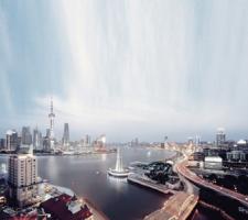
In Beijing and Shanghai (pictured), Viajeo will focus on providing information to public transport users
The ability to bundle together travel data from several discrete sources and fuse it to give a more comprehensive overview of events to stakeholders is the key aim of Viajeo, which is conducting trials in several cities around the world. Here,
Local authorities, ITS service providers and infrastructure operators have invested a considerable amount of money in data collection. Fixed sensors such as loops and automatic number plate recognition cameras) and floating vehicles have been deployed in order to collect real-time data. However, ownership issues lead to the situation where data collected by one operator or service provider cannot be shared by others - whether in real time or after the fact. For example, many bus companies have equipped their fleets with GPS and GSM-equipped OnBoard Units (OBUs) in order to monitor their vehicles' locations and speeds. While the data collected thus is used for real-time operation, it is also accumulated into historical databases which are used for the evaluation of service quality (for example, punctuality and timetable planning). Without data-sharing, such data is not used as floating vehicle data by traffic control operators. Moreover, traffic data collected by traffic control operators cannot be used by bus companies for either real-time operation or route and timetable planning. Sharing data can not only avoid duplication of effort but can also increase data quality and coverage.
This ongoing lack of data sharing has been well recognised and many efforts have been made to solve the issue. Data ownership can be addressed by agreements between different organisations. However, data collected by different operators varies in format and quality and this can make sharing difficult. Therefore, it is necessary to develop an open platform which is able to connect different sources and users and facilitate sharing.
An open platform
There are several companies which provide commercial traffic data platforms. Those commercial platforms are able to gather data from different sources and provide analyses and forecasts. Examples are PTV AG's TrafficPlatform andThe idea of an open platform is aimed at providing a series of interfaces based on European standards which are able to link different data sources, including the outputs of different platforms. The Viajeo project aims to develop just such an open platform and demonstrate its use in four cities. Since Mizar and PTV are key partners in the project, the open platform will be validated by harmonising the inputs and connecting the outputs of the two platforms. The four cities in which the open platform will be demonstrated are Athens, São Paulo, Beijing and Shanghai. In these locations there are various data collection methods in use and a number of traffic information services available. The open platform will then connect existing data sources and services and facilitate information sharing, thus enhancing existing information quality and generating new information.
The Viajeo Beijing demo site, for example, involves Thetis, the Beijing Transportation Research Centre (BTRC), Beijing Public Transport Holdings (BPT) and PTV AG. Beijing has a comprehensive transport analysis platform provided by the BTRC. The platform collects real-time floating vehicle data from 10,000 taxis and this is used for dynamic route guidance, to feed traveller information services and in the development of transport strategies. BPT is a major company, operating over 28,000 buses and 861 bus routes in Beijing. Many BPT buses have been equipped with OBUs which provide real-time location information. The open platform will integrate BPT buses' data with BTRC floating vehicle data to enhance coverage and quality. BPT operators can access real-time traffic state and short-term forecast data from the open platform and use the information for its real-time operations and long-term bus route and operations planning. Thetis, an Italian ITS company which currently runs a traveller information service in Beijing, will use BTRC floating vehicle data and BPT data via the open platform to provide dynamic bus arrival times, public transport interchange information and multimodal journey planning services.
The demonstration
Various functionalities of the open platform will be demonstrated in the four demo cities based on their current situations such as data availability, existing traveller information services, transport policy, characteristics of social and economical developments and so on. It should be noted that Viajeo does not aim to provide innovative services but enhance services with better quality and more availability through applications of the open platform.In Athens, the existing Infotrip traffic platform will be able to connect to the city's traffic management centre. Floating car (mainly from the local taxi fleet) and fixed-sensor data will be integrated. This integrated data will be used to provide real-time traveller information, dynamic route guidance and, moreover, to calibrate an existing dynamic traffic assignment model. Real-time traffic information will be delivered to end users via internet services provided by Infotrip and Mizar, OBUs and displays provided by ANCO and Magneti Marelli Italia.
Unlike in other demo cities, there are currently only a few traveller information services available in São Paulo. However, there are various data sources available in the city and on surrounding motorways which can be used for traveller information services and the establishment of a sound historical traffic database. Implementation of the open platform will play a significant role in accelerating deployment of traveller information services. The open platform will be able to access traffic (flow, volume, speed and incident) data on motorway networks in the São Paulo region. The traffic data on the motorway network is collected by the automatic vehicle identification technologies used for tolling purposes. Floating vehicles will be used to collect travel time data and to detect congestion on the city's urban road network. The open platform will integrate the data to provide a sound understanding of the traffic situation in real time. The data will also feed into a newly established database which will be used for modelling development and planning.
In Beijing and Shanghai, the Viajeo project focuses on providing information to public transport users rather than to motorists. Beijing and Shanghai are experiencing fast growth of car ownership levels as a result of the economic boom in China. That growth creates considerable pressures on the road networks in both cities. Despite large investments in infrastructure improvements, congestion and air pollution from road traffic are still serious issues. Therefore, current policy from local authorities in the two cities aims at reducing car journeys and encouraging use of public transport services. Beijing and Shanghai have comprehensive traffic data collection and management systems. The open platform will enable traveller information service providers to access existing traffic data. Therefore, a company can run its traveller services without collecting its own data. This will significantly reduce capital and operating costs and also enhance quality of information. Good traveller information services, particularly for public transport users, will also address the issue of private car dependency.
In Beijing, Thetis will use floating vehicle data from the BTRC and bus location data from BPT via the open platform to operate displays at bus stops showing real-time bus arrival times and kiosks at interchanges providing interchange information. Thetis will also operate a Web-based multimodal journey planner and an en route information service via mobile phone. In Shanghai, use of the open platform will mainly focus on development of more comprehensive historical databases for transport planning and policy advice. The open platform will be able to access and accumulate real-time traffic data from the local TMC and integrate it with environmental data into a historical database. This database will be used to develop air pollution models. By analysing the database, air pollution hot spots caused by road traffic can be identified. The database will also be used to study the impacts on air pollution of different traffic operation strategies.


