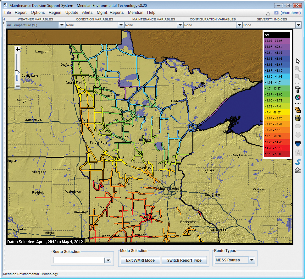
The MDSS archives weather data including variability of air temperature on a route-by-route basis
A US pooled fund study group has developed a system of software aimed at taking the concept of winter maintenance decision support to a new level – a scientific ‘one-stop-shop’ of weather and service performance data. This report is by Charles Chambers and Benjamin Hershey.
With advancements in environmental technology come new systems that assist agencies with better management of winter roadway maintenance resources. In the late 1990s the USThe FHWA defines MDSS as ‘a decision support tool that integrates relevant road weather forecasts, coded maintenance rules of practice and maintenance resource data to provide winter maintenance managers with recommended road treatment strategies’. By this definition, any number of systems providing recommended maintenance practices could be labelled as an MDSS. A wide variety of different MDSS have developed, with a diversity of ways to make use of single systems.
Using the FHWA prototype for MDSS as an initial concept, a new pooled fund study (PFS) group set out in 2002 to expand the guiding principles and take the concept to a new level by developing its own operational MDSS. Leading the PFS development of MDSS was
One-stop-shop
The PFS group’s goal was to develop a comprehensive and actionable software solution to better support the road weather community and improve use of available resources. Two further aims would be essential for fulfilling the overall vision:The first was to provide reliable maintenance recommendations using a scientific approach based not only on the expected weather, but also on conducted maintenance activity and agencies’ goals and constraints of budget, levels of service and personnel or equipment limitations.
The second feature was to be a ‘one-stop-shop’, providing customers with detailed information, such as National Weather Service alerts, data from road weather information systems (RWIS), live traffic images, tailored weather and pavement forecasts, and automated vehicle location (AVL) and maintenance data collection (MDC) – all through a single system.
The PFS group began with five states, and has since expanded the project to include 16 ‘snow and ice’ states. One of the original members in 2002 was the
MnDOT was eager to deploy an MDSS solution to maximize efficiency of its winter maintenance practices, therefore to improve safety of road conditions and increase the efficiency of the department’s use of materials and other resources.
Improving practice
Beyond maintenance recommendations, MnDOT management was also interested in the potential for data collection through the MDSS. The new system would provide ability to measure and record various components of maintenance activities, such as material use, blade wear and overtime spent. The agency could analyze the use of these components to achieve higher levels of accountability. It would also be able to improve practices required to meet desired levels of service, and recognize areas where training is needed, while delivering road condition information to the public in a timely manner.The initial years of the PFS MDSS project were used to study the benefits and potential return on investment of the MDSS. Completion of this research encouraged MnDOT to proceed with a large scale deployment of the decision support system throughout the agency, the goal being to ultimately integrate it into everyday operations.
The implementation process included deployment of the system in one district of the state, then later extension to other test areas that provided more representative conditions around other parts of the state.
This strategy required coordination among the different groups within MnDOT, but allowed the state to evaluate the performance of the system under a variety of conditions.
Essential to the deployment of MDSS at MnDOT was completion of a benefit to cost ratio study to evaluate the return on investment made in the new system. Data from a group of three states within the PFS, including Minnesota, was collected and examined. In all cases the use of MDSS resulted in a positive B/C ratio.
The study also demonstrated there was more than one way to implement the MDSS and realise the benefits of the system. An agency could use MDSS to either raise level of service while maintaining resource use, or maintain current levels of service and improve resource usage. In both cases the MDSS contributes by optimizing the timing and effectiveness of the operations.
Spatial deployment
As of summer 2012, MnDOT has more than 350 snowplow routes and over 100 AVL-equipped maintenance vehicles configured within the PFS MDSS. Routes are distributed throughout six of the state’s seven districts.One consideration in the spatial deployment of MnDOT’s MDSS routes was its vast RWIS network. To make sure the RWIS network is well represented within the MDSS, routes in close proximity to RWIS locations were selected. Using this strategy the RWIS road and weather data can be used to help verify the road information from the MDSS model data and vice versa.
The current distribution of MnDOT’s MDSS routes provides ample opportunity to study how the system performs in varying conditions; from an urban metropolitan area where the weather can be heavily influenced by proximity to a lake, such as the city of Duluth, to the more rural northwestern portion of the state where blowing snow can pose a significant problem when the weather passes over level terrain.
This variety has been crucial in developing MnDOT’s understanding of how the MDSS can be utilized from one location to another across the whole deployment.
An added benefit realised by MnDOT is the use of MDSS outside of wintertime operations.
Enhancements of the system in recent years have been completed with the motivation of promoting use outside snow and ice seasons.
MDSS provides forecast-based recommendations as to whether certain summertime operations should be restricted due to weather conditions.
MnDOT has made use of this feature since 2010, using the information from the system to guide decisions on operations such as cold mix patching, concrete repair and microsurfacing etc. MnDOT continues to operate its MDSS system and the deployment is still expanding year on year.
The vision is to eventually support all of the state’s snowplow routes with the system. MnDOT’s contributions to the project and the successes of the state’s deployment continue to be a vital resource to development and enhancement of the MDSS, and a model for other agencies considering an MDSS deployment of their own.


